


 informatics
Similar presentations:


")


Other SDI services
1.
1Theme 7. OTHER SDI SERVICES
2.
21. In the preceding themes we have discussed three types of
services that are fundamental to any SDI: Data Catalogues,
Web Mapping and data access.
2. Additional services that extend functionality over the Web
by combining data from sources described in Theme 6 are
described here.
3. The application of special services, and service chaining,
hold great promise in realizing true Web-based GIS
interactions on data in support of decision making.
3.
37.1. Context and rationale of SDI services
1. Services can be defined as self-contained, self-describing,
modular applications consisting of collections of operations,
accessible through interfaces, which allow clients to evoke
behaviors of value to the user.
2. Clients can invoke services from across a network using
standardized protocols independently of platform, language,
or object model on which the services or the client were
deployed.
3. By building applications to common service interfaces,
applications can be built without a-priori or run-time
dependencies on other applications or services.
4. Applications and services can be added, modified, or
replaced without impacting other applications.
5. In addition, operational workflows can be changed on-thefly, allowing rapid response to time-critical situations.
4.
47.2. Organisational approach to SDI services
1. As described in the OGC Service Framework, a broad
range of other geospatial services may exist in SDIs.
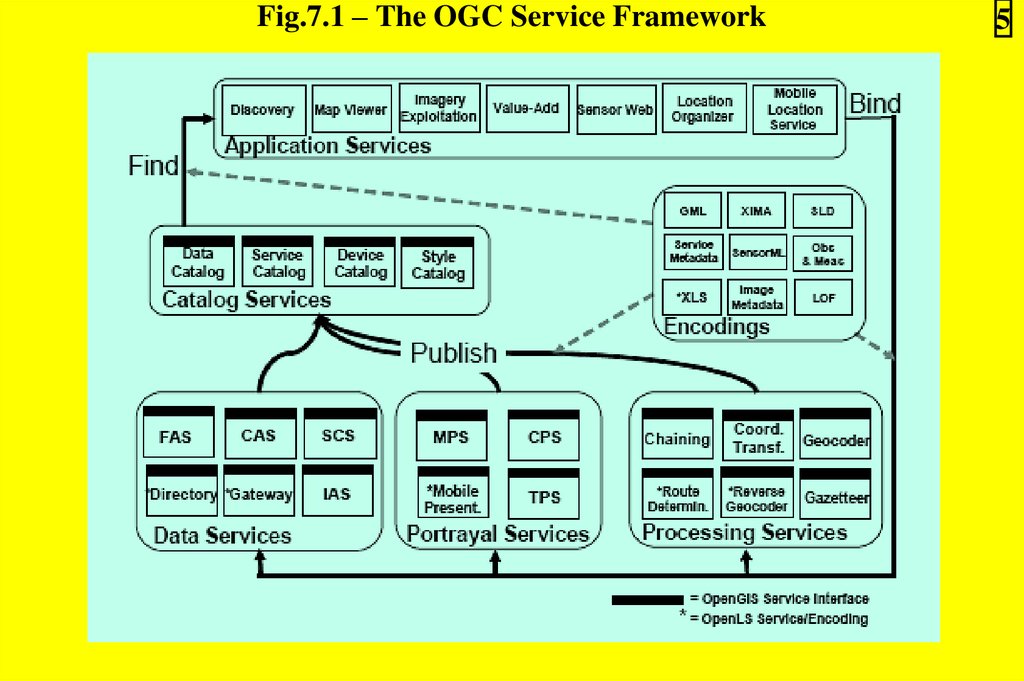
2. The OGC Service Framework (shown in Figure 7.1)
identifies services, interfaces and exchange protocols that can
be utilized by any application.
3. The framework, which can be implemented in different
ways, primarily provides a basis for coordinated development
of new and extended spatial services.
5.
Fig.7.1 – The OGC Service Framework5
6.
64. The OGC Service Framework groups spatial services into
five categories (Table 7.1) corresponding to the OGC
services taxonomy top-level domains described in OGC’s
Service Architecture Abstract Specification (also ISO 19119).
5. By providing a summary of these categories, this theme is
intended to help you decide on the right mix of services that
you need in your applications.
6. Service Chaining is distinguished as one more category of
services.
7.
7Table 7.1 – Categories of the OGC Service Framework
8.
87.2.1. Spatial Application Services:
1) Operate on user terminals (e.g. desktop, notebook,
handset, etc.) or servers to provide access to the various
services described below;
2) Are used by users to access Catalog, Data, Portrayal and
Processing Services depending on the requirements and the
designed implementation of the application;
3) Often provide user-oriented displays of spatial content
and support user interaction at the user terminal.
7.2.2. Catalogue Services:
– Catalogue Services are described in detail in Theme 4.
9.
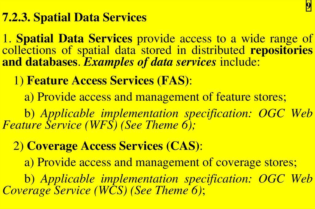
97.2.3. Spatial Data Services
1. Spatial Data Services provide access to a wide range of
collections of spatial data stored in distributed repositories
and databases. Examples of data services include:
1) Feature Access Services (FAS):
a) Provide access and management of feature stores;
b) Applicable implementation specification: OGC Web
Feature Service (WFS) (See Theme 6);
2) Coverage Access Services (CAS):
a) Provide access and management of coverage stores;
b) Applicable implementation specification: OGC Web
Coverage Service (WCS) (See Theme 6);
10.
103) Sensor Collection Services (SCS):
a) Provide access, manipulation and collection of sensor
observations;
b) Applicable implementation specification: OGC Sensor
Collection Service (SCS);
4) Image Archive Services:
– Provide access and management of large sets of digital
images and related metadata.
11.
112. Spatial Data Services also provide access to locationbased data in the form of the following services (Applicable
implementation specification: OGC Location Services, OLS):
1) Directory Services:
– Provide access to online directories to find the locations
of specific or nearest places, products or services;
2) Geocoding Services:
– Transform a description of a location into a normalized
description of the location;
3) Navigation Services:
– Determine travel routes and navigation between two points;
4) Gateway Services:
– Find the position of a known mobile terminal from the
network.
12.
127.2.4. Portrayal Services:
1) Provide visualization of spatial information;
2) Given one or more inputs, services produce rendered
outputs (maps, perspective views of terrain, annotated
images, etc.);
3) Can be tightly or loosely coupled with other services
such as the Data and Processing Services;
4) Can transform, combine, or create portrayed outputs;
13.
135) Examples of such services include:
a) Map Portrayal Services (MPS):
– Described in detail in Theme 5 (See WMS).
b) Coverage Portrayal Services (CPS):
– Applicable implementation specification:
Coverage Portrayal Service (CPS);
c) Mobile Presentation Services etc.
OGC
14.
147.2.5. Processing Services
1. Processing Services are not associated with specific
datasets.
2. They provide operations for processing or transforming
data in a manner determined by user-specified parameters.
3. They can be tightly or loosely coupled with other services
such as the Data and Portrayal Services.
4. The most common examples of processing services are:
1) Coordinate Transformation Services (CTS):
a) Convert spatial coordinates from one reference system
to another;
b) Applicable implementation specification: Coordinate
Transformation Services (CTS);
15.
152) Image Processing Services, which include:
a) Image Manipulation Services:
– Manipulate images (resizing, changing color and
contrast values, applying various filters, manipulating image
resolution, etc.);
– Are used for conducting mathematical analyses of
image characteristics (computing image histograms,
convolutions, etc.);
16.
16b) Image Exploitation Services:
– Support the photogrammetric analysis of remotely
sensed and scanned imagery;
– Support the generation of reports and other products
based on the results of the analysis.
c) Image Synthesis Services:
– Create or transform images using computer-based
spatial
models,
perspective
transformations,
and
manipulations of image characteristics to improve visibility,
sharpen resolution, and/or reduce the effects of cloud cover or
haze;
17.
173) Spatial Analysis Services:
a) Exploit information available in a Feature or Feature
Collection;
b) Derive application-oriented quantitative results that
are not available from the raw data itself.
4) Gazetteers:
a) Provide access to geospatial data indexed by
placename rather than by coordinate locations;
b) Applicable implementation specification: Gazetteer
service profile of a WFS.
18.
7.2.6. SDI Service Chaining18
1. Chaining services can be considered as a special case of
processing services (or separate service category), enabling
the combination or pipelining of results from different
services in response to clients’ requests.
2. Efficient service chaining is critical to your ability to
leverage and combine multiple information sources hosted by
various service providers.
3. The key to achieving such efficiency relies on the use of
standard interfaces and encodings in the design of the
underlying services.
4. Service chaining is required when a task needed by a client
cannot be provided by a single service, but rather by
combining or pipelining results from several complementary
services.
19.
195. Indeed, most GIS applications will require the chaining of
multiple spatial and non-spatial services.
6. Figure 7.2 shows a typical Service Chaining scenario
where:
1) Coverage Portrayal Service (CPS) fetches several GIS
coverages from different WCS services;
2) Then CPS mosaics them to portray the resulting
composite image;
3) Processing Service reprojects the resultant coverage to
another spatial reference system;
4) Overlay Service then supplements the coverage with
features extracted from a WFS, and sends the result to the
client as a rendered map.
20.
Fig.7.2 – A typical Service Chaining example20
21.
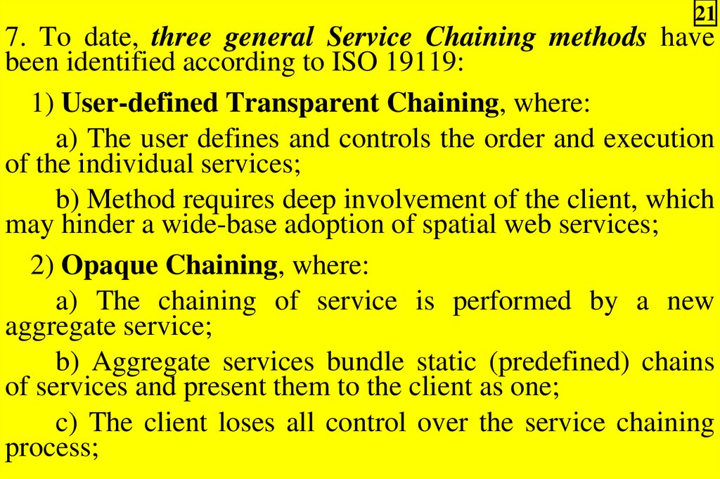
217. To date, three general Service Chaining methods have
been identified according to ISO 19119:
1) User-defined Transparent Chaining, where:
a) The user defines and controls the order and execution
of the individual services;
b) Method requires deep involvement of the client, which
may hinder a wide-base adoption of spatial web services;
2) Opaque Chaining, where:
a) The chaining of service is performed by a new
aggregate service;
b) Aggregate services bundle static (predefined) chains
of services and present them to the client as one;
c) The client loses all control over the service chaining
process;
22.
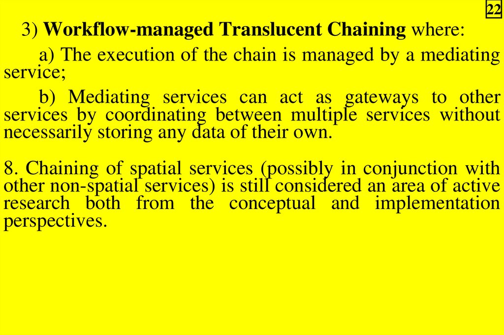
223) Workflow-managed Translucent Chaining where:
a) The execution of the chain is managed by a mediating
service;
b) Mediating services can act as gateways to other
services by coordinating between multiple services without
necessarily storing any data of their own.
8. Chaining of spatial services (possibly in conjunction with
other non-spatial services) is still considered an area of active
research both from the conceptual and implementation
perspectives.
23.
237.3. Implementation approach to SDI services
1. There are few existing standards and protocols for
providing spatial domain services in an interoperable manner.
2. If you need to implement any of these services in your
production environment, it is advisable that you first try to
reuse existing interfaces to the extent possible.
3. You should also work with others in your field and with
applicable standards bodies to design standard interfaces that
can meet your needs.
24.
244. By ensuring that new services fit within the described
OGC Service Framework and are consistent with existing
standards and abstract specifications, you contribute to the
sustainability and extensibility of architectures based on that
framework.
5. In terms of supporting technologies, work is underway
within OGC to define a suite of Web Service Interfaces that
have explicit bindings for both HTTP GET and POST (e.g.
the WMS, WFS and WCS specifications).
6. In this case, XML is very fundamental as it provides the
extensibility and vendor, platform and language
independence that are key to the loosely coupled standardsbased interoperability.
25.
257. As for Service Chaining, work is still under way to enable
it using existing and emerging XML technologies, such as:
1) The Web Services Description Language (WSDL),
which:
a) Provides a way to describe the messages and
operations of a service in an abstract way and bind them to a
concrete protocol and message format;
b) In the case of GIS services, describing the service
interfaces is often not enough;
2) The Universal Description, Discovery and
Integration (UDDI) which:
a) Enables businesses to quickly and dynamically find
and transact with each other;
b) Do not currently support any type of spatial queries;
26.
263) The Simple Object Access Protocol (SOAP) which;
– Provides a simple and light-weight mechanism of
exchanging structured and typed information between peers
in a decentralized distributed environment;
4) DAML-based Web Service Ontology (DAML-S) which:
– Supplies Web Service providers with a core set of
markup language constructs for describing the properties and
capabilities of their Web Services;
5) The Business Process Execution Language for Web
Services (BPEL4WS) which:
a) Defines a notation for specifying business process
behavior based on Web Services;
b) Is a standard promoted by Microsoft, IBM etc.
27.
278. It remains to be seen how the listed technologies (and
others) can be leveraged for service description, discovery
and chaining within the spatial domain.
9. As shown in Figure 7.3, in service environment, it will not
be necessary for players to build comprehensive systems in
order to gain a share of the market.
10. The new environment can open the door to small niche
players to enter this market with application specific offerings
that leverage their understanding of particular industries or
processes.
28.
Fig.7.3 – Potential value chain for a service-based GIS marketplace28