


 informatics
Similar presentations:


")


Open spatial access in SDI
1.
1Theme 6. OPEN SPATIAL ACCESS IN SDI
2.
26.1. Preconditions of understanding of spatial access in
SDI
1. Once spatial data of interest have been located and
evaluated, using the Catalogue and Web Mapping techniques,
access to detailed spatial data in its packaged form is often
required by advanced users or application software.
2. Data access is recognized element in a full-service SDI.
3.
6.2. Context and rationale of open spatial access in SDI3
1. Access to spatial data from the consumers point of view is
a part of a process of that goes from discovery to evaluation,
to access and finally to exploitation:
1) Discovery (find, locate) involves the use of services
such as metadata catalogues to find data of particular interest
over a specific geographic region;
2) Evaluation involves detailed reports, sample data and
visualization to help the consumer determine whether the data
is of interest;
3) Access involves the order, packaging and delivery,
offline or online, of the data (coordinate and attributes
according to the form of the data) specified.
4) Finally exploitation (use, employ) is what the consumer
does with the data for their own purpose.
4.
42. With the growth of the Internet access has become a
demand driven operation.
3. Consumers expect simple discover and access to cheap (or
free) data in simple standard formats that can be used in
desktop applications.
4. The further democratization of access to geospatial data
thus enables value-added suppliers to create new data
products and services.
5.
55. Several trends can be noted in the treatment and
handling of spatial data:
1) Typically in the past the first trend concern of a data
custodian has been what format the data is stored or managed
in;
2) Second trend is in the organization of the data itself and
a supplier was empowered to deliver data online;
3) More recently the third trend has been to merge all the
discrete data sets together into single, seamless data
warehouses that have spawned the development of direct data
access services.
6.
66.3. Organisational approach to open spatial access in SDI
6.3.1. Stakeholders' categories in SDI access
1. In most national infrastructures government suppliers are
key stakeholders:
– How they will play in the development and operation of
the data access component of the infrastructure depends
strongly on government policies regarding data distribution,
cost recovery, etc.
2. Commercial entities will generally play a strong role as
providers of tools and services but may also be suppliers of
primary and value added data.
7.
73. The final category of stakeholder is the consumer or enduser:
– Their use of the data access element infrastructure is
dependent on a number of factors including:
1) The functionality of the infrastructure tools;
2) The amount and quality of the content accessible;
3) Operating policies;
4) Infrastructure business model (will consumers be
charged for access?), etc.
8.
86.3.2. Development of policy/organisational environment
for SDI access
1. Potential stakeholders will only become active participants if:
1) They see advantages for their organizations;
2) They do not feel threatened by the infrastructure.
2. This policy/organization environment:
1) Will vary from country to country;
2) Will need to be worked out closely with the stakeholder
community.
3. The buy-in and commitment from senior management of
all stakeholders is critical to the success of the infrastructure
as a whole and to that of the access element in particular.
9.
94. Some of the issues that need to be considered in the
development of the supportive to SDI access
policy/organisational environment are:
1) Distributed/autonomous suppliers;
2) The management of the data should be done as close as
possible to source:
– This ensures the accuracy and quality of the data;
3) Commercial and government stakeholders need to feel
comfortable as active participants in the infrastructure:
– They should not feel threatened by infrastructure
business models or policies;
10.
104) Multiple levels of “buy-in”; low barrier to entry:
a) The access component of the infrastructure must
provide multiple levels of buying from a low cost option with
limited benefits to higher cost options that offer increased
benefits;
b) This allows suppliers to choose a level of participation
that best meets their business and operational objectives;
5) Sustainable long term business models:
a) The access component of an infrastructure must
provide an environment that supports a variety of supplier
business models;
b) The development of a sustainable business model for
the operation of the access component is critical to the long
term success of the entire infrastructure.
11.
115. The role the private sector as suppliers of data,
services, and technology and as potential operators of the
SDI access must be clearly defined.
12.
126.3.3. Marketing and promotion of SDI access
1. The access component of an infrastructure must develop a
marketing and promotion plan to build up the level of
awareness and participation as quickly as possible.
2. It is important to get a critical mass of suppliers so
potential participants will see the benefits of joining the
infrastructure.
13.
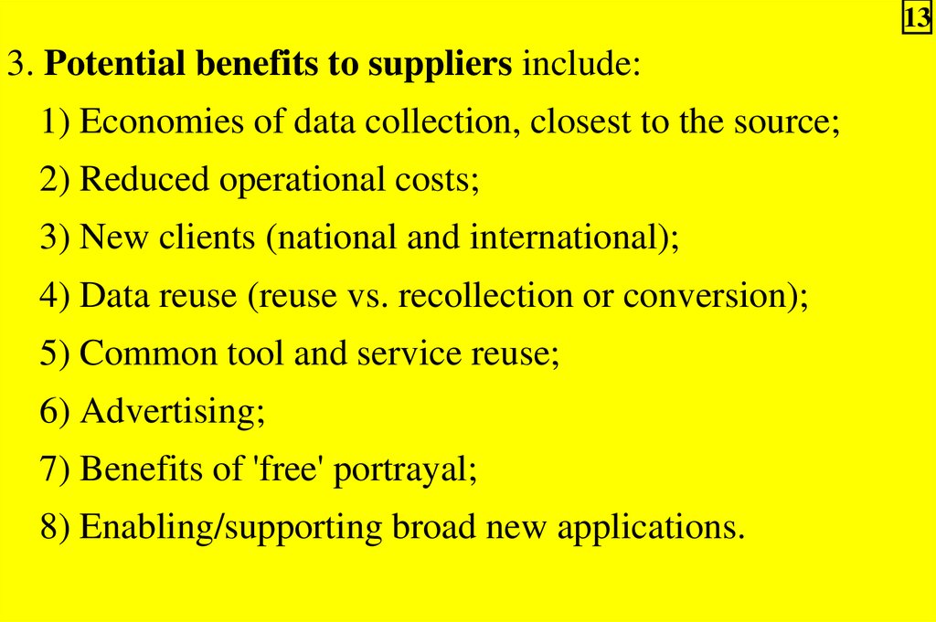
133. Potential benefits to suppliers include:
1) Economies of data collection, closest to the source;
2) Reduced operational costs;
3) New clients (national and international);
4) Data reuse (reuse vs. recollection or conversion);
5) Common tool and service reuse;
6) Advertising;
7) Benefits of 'free' portrayal;
8) Enabling/supporting broad new applications.
14.
146.4. Implementation approach to open spatial access in
SDI: definitions and overview
6.4.1. Data sets in SDI access
1. Data sets are described by metadata and maintained within
a data store.
2. Core and Framework data sets are data that may be present
within a spatial data infrastructure (See Theme 2).
3. Data sets are composed of:
1) Collections of features (e.g. roads, rivers, political
boundaries, etc.);
2) Coverages (e.g. satellite/airborne imagery, digital
elevation models, etc.).
15.
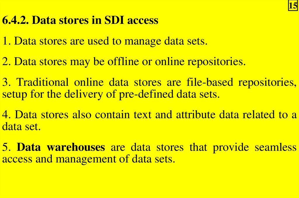
156.4.2. Data stores in SDI access
1. Data stores are used to manage data sets.
2. Data stores may be offline or online repositories.
3. Traditional online data stores are file-based repositories,
setup for the delivery of pre-defined data sets.
4. Data stores also contain text and attribute data related to a
data set.
5. Data warehouses are data stores that provide seamless
access and management of data sets.
16.
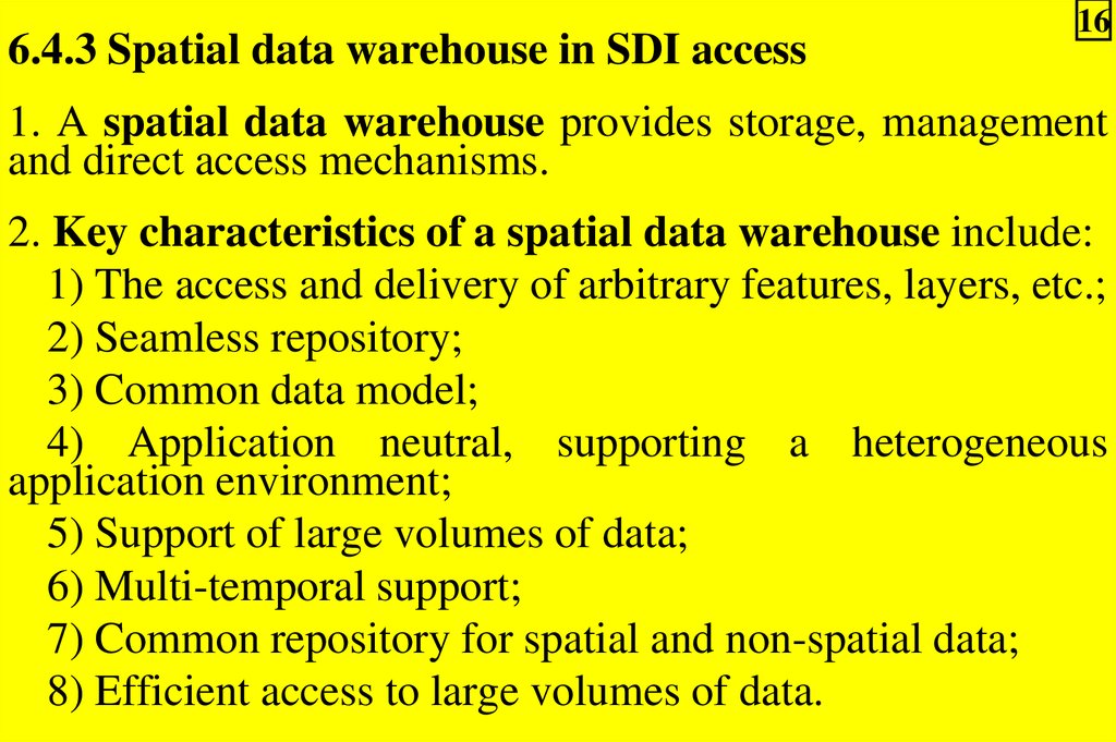
6.4.3 Spatial data warehouse in SDI access16
1. A spatial data warehouse provides storage, management
and direct access mechanisms.
2. Key characteristics of a spatial data warehouse include:
1) The access and delivery of arbitrary features, layers, etc.;
2) Seamless repository;
3) Common data model;
4) Application neutral, supporting a heterogeneous
application environment;
5) Support of large volumes of data;
6) Multi-temporal support;
7) Common repository for spatial and non-spatial data;
8) Efficient access to large volumes of data.
17.
173. Examples of commercial data warehousing and service
solutions for geospatial data include:
a) Cubestore from Cubewerx
(http://www.cubewerx.com/);
b) The Oracle Spatial solution
(http://otn.oracle.com/products/oracle9i/datasheets/spatial/
spatial.html);
c) ESRI Spatial Data Engine
(http://www.esri.com/).
18.
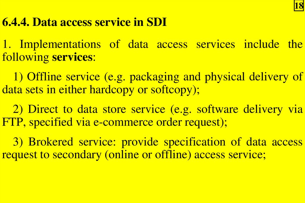
186.4.4. Data access service in SDI
1. Implementations of data access services include the
following services:
1) Offline service (e.g. packaging and physical delivery of
data sets in either hardcopy or softcopy);
2) Direct to data store service (e.g. software delivery via
FTP, specified via e-commerce order request);
3) Brokered service: provide specification of data access
request to secondary (online or offline) access service;
19.
194) Online data service (e.g. request/response access
protocol to data warehouse) supporting online operations
such as:
a) Drill down;
b) Aggregation;
c) Generalization.
2. In Open Geospatial Consortium Project Document 98-060:
"User Interaction with Geospatial Data” the OGC Portrayal
model is described. Figure 6.1 describes this model, which
illustrates a simple features-based access and portrayal
(presentation of information to humans) services pipeline.
20.
Fig.6.1 – OGC Portrayal model20
21.
216.4.5. SDI data access clients
Online implementations of data access clients include:
1) 'Thin client', which is provided by standard
Internet/Web tools (no Java – e.g. Web browser, e-mail, FTP
client, etc.);
2) 'Medium client', which is provided by Web browser
with Java, or ActiveX controls;
3) 'Thick client', which is provided by a Web browser
plugin, or standalone application (network access via a
distribution computing platform such as CORBA, Java RMI,
etc.).
22.
226.4.5. SDI data access clients:
4) Traditional GIS type client, which need access to
previously downloaded data set, and direct network access to
data warehouse;
5) 'Middleware client', which need transparent access to
consumer via a middleware infrastructure or applications
service;
6) Geoprocessing service client – direct access to data for
use by a geoprocessing service (e.g. Web Mapping with
interactive portrayal service).
23.
236.4.6. SDI data formats
Common spatial data formats used in SDI include the following.
1. GIS proprietary formats (e.g. ESRI, MapInfo,
Intergraph, etc.):
– A good overview of GIS formats can be found at
http://www.gisdatadepot.com/helpdesk/formats.html
2. International and community formats:
1) Efforts have recently been made to minimize the number
of geodata formats and to converge towards a reduced set;
2) Examples of this are:
a) The Spatial Data Transfer System (SDTS),
b) ISO TC/211;
c) The DIgital Geographic Exchange STandard (DIGEST);
24.
243) There are also exchange formats that allow the use of
data outside of closed environments:
– E.g. Geography Markup Language.
4) Due to lack of consensus on specific format standards,
spatial data infrastructures often support access to multiple
spatial data formats through data access services;
5) However, if it is feasible, the definition of a single
community format based on ISO and OGC specifications is
ideal to promote information exchange (See Theme 2);
25.
256) Currently, most GIS and related access systems support
format translation. Examples of commercial support for
format translation include:
a) The Feature Manipulation Engine from Safe Software
(http://www.safe.com/);
b) Geogateway from PCI
(http://www.pci.com/);
7) An online data access service that combines data access
with format translation is the Open Geospatial Datastore
Interface (http://ogdi.sourceforge.net).
26.
263. Web implementation formats
Vector files:
1) There are a three candidate file formats for encoding
vector information on the WWW:
a) Simple Vector Format (SVF);
b) Web Computer Graphics Metafile;
c) XML-based encoding formats, e.g. GML;
2) Only GML is specifically designed for the encoding of
vector geographic information;
3) The other formats are designed for the exchange of
vector graphic information but may have little or no reference
to real world or mapped coordinate systems or feature
content.
27.
27Raster files:
1) Web/internet delivery of GIS raster formats such as
ADRG, BIL and DEM is often problematic due to the large
size of such files, combined with general lack of Internet
bandwidth;
2) Typically compressed raster files predominate Webbased portrayals;
3) Common compressed Web formats include GIF, JPEG
and PNG to move single variable panchromatic or color
images as raster files.
28.
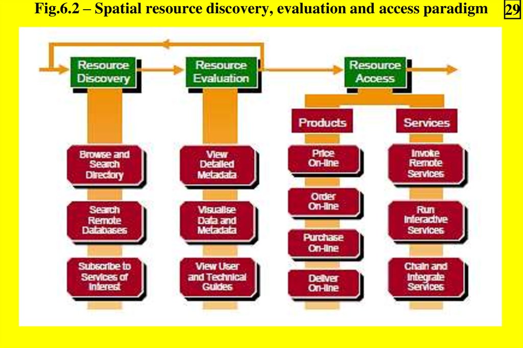
286.5. SDI data access's relationship to other SDI services
1. Figure 6.2 illustrates the relationship role of data access in
an end-to-end spatial resource discovery, evaluation and
access paradigm.
2. Successive iterations of resource discovery via a metadata
catalogue, followed by resource evaluation (such as Web
Mapping) lead to data access either:
1) Direct as a data set;
2) Indirect via a data access service.
3. Mature spatial data infrastructure will allow both
application and human exploitation of the resource access
paradigm.
4. A key element of future spatial data infrastructures is the
ability to broker requests for services, based on discovery and
real-time access to online geoprocessing and related services.
29.
Fig.6.2 – Spatial resource discovery, evaluation and access paradigm29
30.
305. Future capability for chaining of distributed geoprocessing
services is also expected.
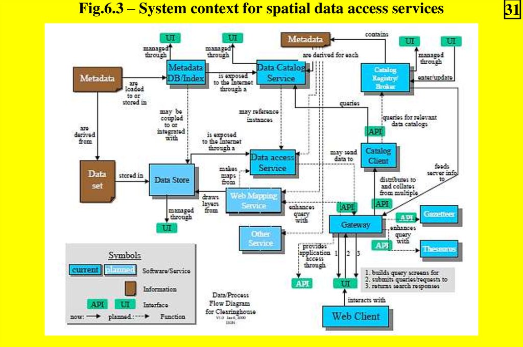
6. A system context for spatial data access services is given
in Figure 6.3:
1) A data access service provides network access to a data
set stored within a data store;
2) Data sets are discovered (and later accessed) via
metadata queries from a catalogue client to a data catalogue
service;
3) Data sets can be visualized (and later accessed) via Web
Mapping Services, which are complementary to the Data
Catalogue Service.
31.
Fig.6.3 – System context for spatial data access services31
32.
326.6. SDI data access standards
In general, standards related to spatial data access are still in
their infancy.
The standards of most relevance to access components of
spatial data infrastructures include those from:
1) ISO/TC211;
2) Open GIS Consortium (OGC);
3) Internet-related bodies including:
a) The World Wide Web consortium (W3C);
b) The Internet Engineering Task Force (IETF).
33.
336.6.1. ISO/TC211 data access standards
1. The primary mandate of ISO/TC211 is international
standardization in the field of digital geographic information.
2. These ISO standards may specify, for geographic
information, methods, tools and services for data
management (including definition and description), acquiring,
processing, analyzing, accessing, presenting and transferring
such data in digital/electronic form between different users,
systems and locations.
3. Work on such services is currently underway in both
ISO/TC211 and the OGC.
4. The definition of services interfaces will allow a wide
range of applications access and use of spatial resources.
5. The OGC Features Model for SQL has been submitted to
ISO for standardization (See further).
34.
346.6.2. Open GIS
specification
Consortium (OGC)
data access
1. The Open GIS Consortium has achieved consensus on
several families of interfaces, and some of these have now
been implemented in Off-The-Shelf software.
2. The publication of the OGC Web Feature Service (WFS)
Specification in 2002 provided a solution for the
standardized request and delivery of vector data.
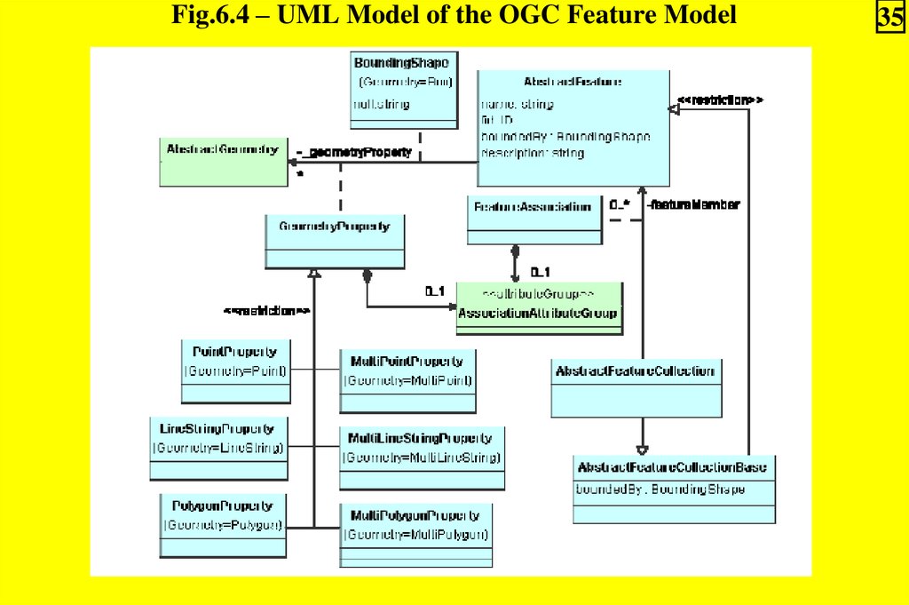
3. Supporting the OGC Feature Model shown in Figure 6.4,
the WFS specification defines the dialogue required to
interact with geographic features via vector data service.
35.
Fig.6.4 – UML Model of the OGC Feature Model35
36.
364. Web Feature Service (WFS):
1) A service that can describe data manipulation operations
on OGC simple features (feature instances) such that servers
and clients can "communicate" at the feature level;
Note. Simple feature – feature restricted to 2D geometry
with linear interpolation between vertices, having both spatial
and non-spatial attributes.
2) A Web Feature Server request consists of a description
of the query and data transformation operations that are to be
applied to WFS Web-enabled spatial data;
3) The request is generated on a client and is posted to the
WFS Server.
4) The WFS Server interprets the request, checks it for
validity, executes the request and then returns a feature set as
GML to the client, which then can use the feature set.
37.
375. The OGC Web Coverage Service (WCS) Specification
was published in 2003.
6. It extends the Web Map Service (WMS) interface to allow
access to spatial "coverages", rather than WMS generated
maps (pictures).
7. Web Coverage Service (WCS):
1) A service that supports the networked interchange of
spatial data as coverages containing values or properties of
geographic locations;
2) The WCS provides access to intact (unrendered) spatial
information, as needed for client-side rendering, multi-valued
coverages and input into scientific models and other clients
beyond simple viewers;
38.
383) Coverage is a feature that acts as a function to return
values from its range for any direct position within its
spatiotemporal domain:
a) A coverage represents continues phenomena;
b) There are different types of coverage – a set of tiled
polygons, a grid of values, a mathematical function, or a
combination of these;
c) Grid coverage represents the value in a grid’s points;
4) WCS provides receiving an array or surface of data
values.
39.
398. The OGC Web Coverage Service (WCS) Specification
have also been released to support feature access in relational
database environments: one each for SQL, COM-based, and
CORBA distributed computing platforms.
9. The WCS interfaces provide access to and control over
GIS features at 3 levels:
1) At the primitive level, the interfaces provide for the
establishment of linear and angular units, spheroids, datums,
prime meridians, and map projections that give semantics to
coordinates;
2) At the intermediate level, they enable the construction and
manipulation of geometric elements such as points, lines, curves,
strings, rings, polygons, and surfaces, as well as the topological
and geometric and other relationships between them;
3) At the GIS feature level, the interfaces provide for
access to feature collections using geometry or attributes for
selection.
40.
406.6.3. Web and Internet related data access specifications
1. The World Wide Web consortium or W3C is responsible
for the development of common protocols and specifications
to further the evolution of the World Wide Web.
2. Activities of the W3C that related to spatial data access
include work on Web graphic file formats, XML and
metadata.
3. The Internet Engineering Task Force (IETF) develops
and maintains specification for many Internet related
application, transport, routing and security standards (RFCs)
many of which are related to data access.
41.
416.7. Best practice application of SDI open data access
1. One common problem with online access to data is the
variety of policies and practice in place by the different data
custodians, which use different basic paradigms:
1) Custodians who restrict access to particular users would
benefit from common user authentication/authorization
services;
2) Custodians who charge for data or services would
benefit from electronic commerce services;
3) Custodians who distribute data free of charge would
benefit from an inexpensive mechanism (both time and
money) to distribute data.
42.
422. One example of services to support the third paradigm is
GeoGratis (http://geogratis.cgdi.gc.ca/) that provides
common services to support the distribution of freely
available geospatial data.
3. GeoGratis provides a single FTP/web access point where
consumers can discover and download freely available data
sets.
43.
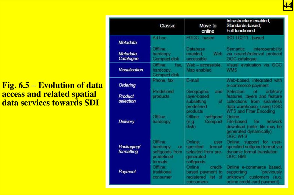
436.8. Evolution of data access and related spatial data
services towards SDI
1. The matrix below (Fig.6.5) illustrates the evolution of data
access and related spatial data services.
2. Migration from “classic” towards “infrastructure enabled;
standards based; and full functioned” is required to bootstrap
a national spatial data infrastructure.
3. Early adoption and “best practices” of such evolution
should be followed by key government data providers.
44.
44Fig. 6.5 – Evolution of data
access and related spatial
data services towards SDI