


 english
Similar presentations:


How Has the Aral Sea Changed Over Time
1. How Has the Aral Sea Changed Over Time?
Sally Student, Sam StudentCircle High School, Mrs. Teacher, grades 6 to 8
2. The Situation
As shown in these satellite images, the AralSea dramatically changed in size from August
2000 through August 2010.
3. About the Aral Sea
The Aral Sea in centralAsia is drying up.
Rivers that once flowed
into the lake have been
diverted to irrigate crops.
Fresh water has
evaporated, increasing the
salinity of the water and
killing many fish.
The Aral Sea is located in Central Asia, between
Kazakhstan & Uzbekistan.
Image credit: World Bank
http://web.worldbank.org/WBSITE/EXTERNAL/COUN
TRIES/ECAEXT/0,,contentMDK:20634287~pagePK:1
46736~piPK:146830~theSitePK:258599,00.html
4.
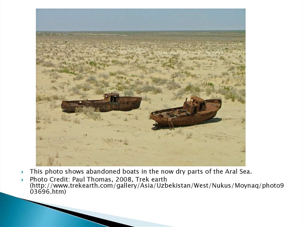
This photo shows abandoned boats in the now dry parts of the Aral Sea.Photo Credit: Paul Thomas, 2008, Trek earth
(http://www.trekearth.com/gallery/Asia/Uzbekistan/West/Nukus/Moynaq/photo9
03696.htm)
5. Problem & Prediction
Research Question: How has the Aral Seachanged over time?
Prediction: We think that the loss of water in
the Aral Sea has occurred at a steady, linear
rate through time and that it could dry up
completely within 10 years.
6. Methods
We used ImageJ to analyze NASA MODISsatellite images from the World of Change
collection at the NASA Earth Observatory
◦ http://earthobservatory.nasa.gov/Features/WorldOfChange/aral_s
ea.php
We also read NASA Earth Observatory
Articles:
◦
◦
◦
◦
http://earthobservatory.nasa.gov/IOTD/view.php?id=1396
http://earthobservatory.nasa.gov/IOTD/view.php?id=2057
http://earthobservatory.nasa.gov/IOTD/view.php?id=3322
http://earthobservatory.nasa.gov/IOTD/view.php?id=3730
7. Data Analysis Steps
1.2.
3.
4.
5.
6.
Import all eleven images into ImageJ to
create a stack
Animate the stack to observe the change
in the area of the lake through time.
Make the year 2000 image active and use
it to set a scale in ImageJ.
Propagate the scale to the remaining
images.
Starting with the 2000 image, use the
straight line selection tool to measure the
distance across the lake at two
recognizable points.
Repeat for the other 10 images (2001
through 2010).
Measuring the distance across
the Aral Sea using the straight
line selection tool in ImageJ for
August 2000 satellite image.
8. Data Analysis Steps
7.8.
9.
10.
Use the free hand selection tool to measure the area of the lake in
each image.
Save and open results into Excel.
Graph results with measurements on the y-axis and years on the xaxis. Create two graphs, one showing the change in distance across
the lake through time and the other showing the change in area of
the lake through time.
Calculate the average annual rate of change in the width and the
area of the Aral Sea from 1960 to 2009.
9. Results for Distance
In 1960, the width across the Aral Sea was 235.625 km. By 2009, that widthwas reduced to 20 kilometers.
Between 1960 and 2009, the Aral Sea shrunk at a rate of approximately 4.3
kilometers in width per year.
10. Results for Area
The area of the Aral Sea was 66,784.3 kilometers squared in 1960, but only4049.74 kilometers squared by 2009.
Between 1960 and 2009, the Aral Sea shrunk at a rate of approximately
approximately 1,255 kilometers squared in area per year..
11. Findings & Discussion
In 1960, the width across the Aral Sea was 235.625 km. By2009, that width was reduced to 20 kilometers.
In a similar manner, the area of the Aral Sea was 66,784.3
kilometers squared in 1960, but only 4049.74 kilometers
squared by 2009.
We took the difference between the 2009 widths and areas
and the 1960 measurements, dividing this difference by the
number of years (50) to calculate average yearly rates of
change.
Between 1960 and 2009, the Aral Sea shrunk at a rate of
approximately 4.3 kilometers in width per year and at a rate
of approximately 1,255 kilometers squared in area per year.
12. Conclusions
Based upon the data we collected and the graphs weproduced, Aral Sea is shrinking at a steady rate through time.
However, because we are missing data from the years 1961
through 1999, it is not possible to characterize the loss as
either a linear or exponential rate.
At our calculated rate of change (1255 squared kilometers
loss in area per year), the Aral Sea could be dry in as few as
3.2 years. These results support our initial hypothesis that
the Aral Sea could be dry within 10 years.
13. Limitations to Our Research
Through the years, the distance loss across the left side ofthe lake is less than on the right side, perhaps because the
left side of the lake is deeper. Changes in the volume of a
three-dimensional shape such as a lake cannot be
characterized very accurately by measuring only one
dimension, such as width or area.
Our projections are based on the assumption that the lake
will continue to lose water in future years. In fact, in 2010,
both the width and the area of the Aral Sea increased. We
measured the width and came up with 126 kilometers. The
area was 9437 kilometers squared. If steps are taken to
replenish the water, then the sea might not dry up after all.
14. Implications for the Future
Through If the Aral Sea continues to shrink, it is in danger ofcompletely drying out. Further loss of the Aral Sea could have
significant negative impacts on agriculture and human health
in surrounding communities and beyond as sand full of salts,
minerals, and toxins gets swept away from the dried up lake
bed. This environmental situation is not limited to the Aral
Sea. We need to monitor our lakes to ensure an adequate
supply of water for the future.