


 geography
Similar presentations:


")


Geography of UK and Northern Irelands. Geography of USA
1. Karaganda state medical university
Department of Foreign LanguagesStudent Individual Work
Theme: Geography of UK and Northern
Irelands. Geography of USA
Prepared by: Kadyr D.
Group:110
Checked by: Kenzhebekova R.S.
Karaganda 2010
2.
3.
United KingdomOfficial Name:
United Kingdom of Great Britain and Northern Ireland
4.
The United Kingdom of Great Britain and NorthernIreland, or UK, is a sovereign state located off the northwestern
coast of continental Europe. It comprises the island of Great
Britain (England, Scotland and Wales) and the northeastern
one-sixth of the island of Ireland (Northern Ireland), together
with many smaller islands. The mainland areas lie between
latitudes 49°N and 59°N (the Shetland Islands reach to nearly
61°N), and longitudes 8°W to 2°E. The Royal Greenwich
Observatory, in South East London, is the defining point of the
Prime Meridian.
The UK lies between the North Atlantic and the North Sea, and
comes within 35 km (22 mi) of the northwest coast of France,
from which it is separated by the English Channel. Northern
Ireland shares a 360 km international land boundary with the
Republic of Ireland. The Channel Tunnel bored beneath the
English Channel, now links the UK with France.
5.
PROFILEGeography
Area: United Kingdom 243,820 km² (94,600 sq mi)
comprising of the island of Great Britain, the northeastern onesixth of the island of Ireland (Northern Ireland) and smaller
islands. England is the largest country of the United Kingdom,
at 130,410 square kilometres (50,350 sq mi) accounting for just
over half the total area of the UK. Scotland at 78,772 square
kilometres (30,410 sq mi),[1] is second largest, accounting for
about a third of the area of the UK. Wales and Northern Ireland
are much smaller, covering 20,758 square kilometres (8,010
sq mi) and 14,160 square kilometres (5,470 sq mi) respectively
6.
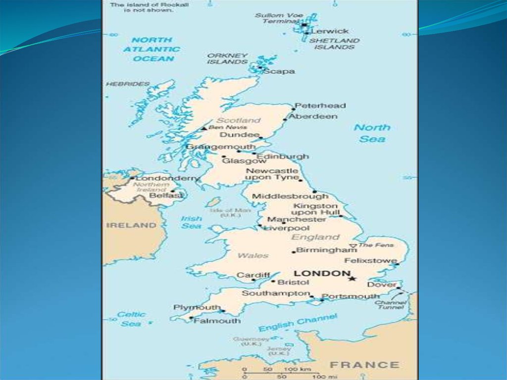
Cities: Capital--London (metropolitan pop. about 7.56 million).Other cities--Birmingham, Glasgow, Leeds, Sheffield, Liverpool,
Bradford, Manchester, Edinburgh, Bristol, Belfast.
Terrain: 30% arable, 50% meadow and pasture, 12% waste or
urban, 7% forested, 1% inland water.
Land use: 25% arable, 46% meadows and pastures, 10% forests
and woodland, 19% other.
Climate: Generally mild and temperate; weather is subject to
frequent changes but to few extremes of temperature.
7.
The area of the countries of the United Kingdom is set out in thetable below. Information about the area of England, the largest
country, is also broken down by region.
Rank Name Area 1 England 130,427 km² South West - 23,837 km²
East of England- 19,120 km²
South East-19,096 km²
East Midlands- 15,627 km²
Yorkshire and the Humber-15,420 km²
North West - 14,165 km²
West Midlands-12,998 km²
North East 8,592 km²
London-1,572 km²
2 Scotland [8] 78,772 km² 3 Wales [9] 20,778 km²
4 Northern Ireland 13,843 km² United Kingdom 243,820 km²
8.
9.
PeopleNationality: Noun--Briton(s). Adjective--British.
Population (2010 est.): 62.2 million.
Annual population growth rate (2010 est.): 0.7%.
Major ethnic groups: British, Irish, West Indian, South Asian.
Major religions: Church of England (Anglican), Roman Catholic,
Church of Scotland (Presbyterian), Muslim.
Major languages: English, Welsh, Irish Gaelic, Scottish Gaelic.
Education: Years compulsory--12. Attendance--nearly 100%. Literacy-99%.
Health: Infant mortality rate (2009 est.)--4.85/1,000. Life expectancy
(2009 est.)--males 76.5 yrs.; females 81.6 yrs.; total 79.0 years.
Work force (2009, 31.25 million): Services--80.4%; industry--18.2%;
agriculture--1.4%.
10.
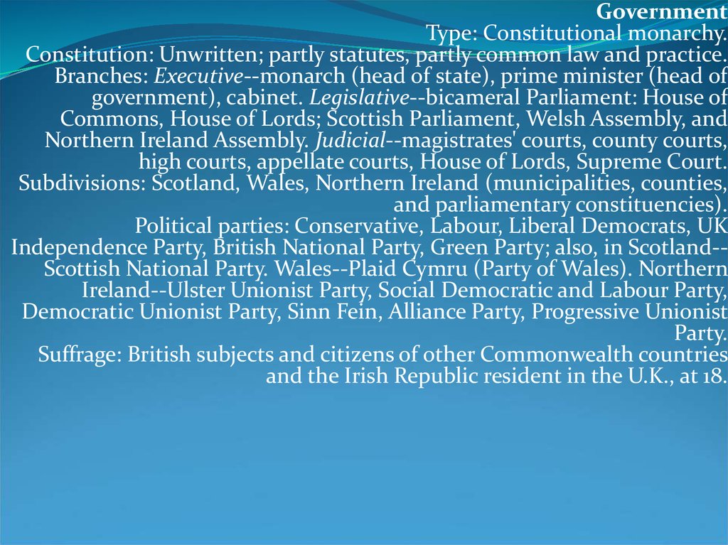
GovernmentType: Constitutional monarchy.
Constitution: Unwritten; partly statutes, partly common law and practice.
Branches: Executive--monarch (head of state), prime minister (head of
government), cabinet. Legislative--bicameral Parliament: House of
Commons, House of Lords; Scottish Parliament, Welsh Assembly, and
Northern Ireland Assembly. Judicial--magistrates' courts, county courts,
high courts, appellate courts, House of Lords, Supreme Court.
Subdivisions: Scotland, Wales, Northern Ireland (municipalities, counties,
and parliamentary constituencies).
Political parties: Conservative, Labour, Liberal Democrats, UK
Independence Party, British National Party, Green Party; also, in Scotland-Scottish National Party. Wales--Plaid Cymru (Party of Wales). Northern
Ireland--Ulster Unionist Party, Social Democratic and Labour Party,
Democratic Unionist Party, Sinn Fein, Alliance Party, Progressive Unionist
Party.
Suffrage: British subjects and citizens of other Commonwealth countries
and the Irish Republic resident in the U.K., at 18.
11.
EconomyGDP (at current market prices, 2009): $2.184 trillion.
Annual growth rate (2009): -4.8%.
Per capita GDP (at current market prices, 2009): $35,334.
Natural resources: Coal, oil, natural gas, tin, limestone, iron ore, salt, clay,
chalk, gypsum, lead, silica.
Agriculture (1.2% of GDP): Products--cereals, oilseed, potatoes, vegetables,
cattle, sheep, poultry, fish.
Industry: Types--steel, heavy engineering and metal manufacturing,
textiles, motor vehicles and aircraft, construction (23.8% of GDP),
electronics, chemicals.
Services (75% of GDP): Types--financial, business, distribution, transport,
communication, hotels.
Trade (2009): Exports of goods and services--$351.3 billion: manufactured
goods, fuels, chemicals; food, beverages, tobacco. Major markets--U.S.,
European Union. Imports of goods and services--$473.6 billion:
manufactured goods, machinery, fuels, foodstuffs. Major suppliers--U.S.,
European Union, and China.
12.
Mountains and hills:Mountains of the United KingdomThe ten tallest mountains in the UK are all found in Scotland. The highest peaks in each part
of the UK are:
Scotland: Ben Nevis (Aonach Mòr, 1,344 metres)
Wales: Snowdon (Snowdonia, 1,085 metres)
England: Scafell Pike (Cumbrian Mountains, 977 metres)
Northern Ireland: Slieve Donard (Mourne Mountains, 852 metres)
The ranges of mountains and hills in the UK include:
Scotland: Cairngorms, Cheviot Hills, Scottish Highlands, Southern Uplands, Grampian
Mountains
Wales: Brecon Beacons, Cambrian Mountains, Snowdonia, Black Mountains, Preseli Hills
England: Chilterns, Cotswolds, Dartmoor, Lincolnshire Wolds, Exmoor, Lake District,
Malvern Hills, Mendip Hills, North Downs, Peak District, Pennines, Salisbury Plain, South
Downs, Shropshire Hills, Yorkshire Wolds
Northern Ireland: Mourne Mountains, Antrim Plateau, Sperrin Mountains
The lowest point of the UK is in the Fens of East Anglia, in England, parts of which lie up to
4 metres below sea level.
13.
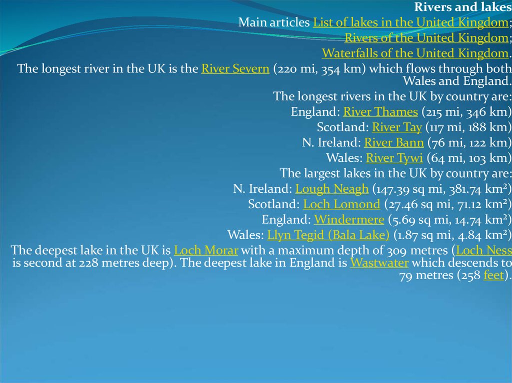
Rivers and lakesMain articles List of lakes in the United Kingdom;
Rivers of the United Kingdom;
Waterfalls of the United Kingdom.
The longest river in the UK is the River Severn (220 mi, 354 km) which flows through both
Wales and England.
The longest rivers in the UK by country are:
England: River Thames (215 mi, 346 km)
Scotland: River Tay (117 mi, 188 km)
N. Ireland: River Bann (76 mi, 122 km)
Wales: River Tywi (64 mi, 103 km)
The largest lakes in the UK by country are:
N. Ireland: Lough Neagh (147.39 sq mi, 381.74 km²)
Scotland: Loch Lomond (27.46 sq mi, 71.12 km²)
England: Windermere (5.69 sq mi, 14.74 km²)
Wales: Llyn Tegid (Bala Lake) (1.87 sq mi, 4.84 km²)
The deepest lake in the UK is Loch Morar with a maximum depth of 309 metres (Loch Ness
is second at 228 metres deep). The deepest lake in England is Wastwater which descends to
79 metres (258 feet).
14.
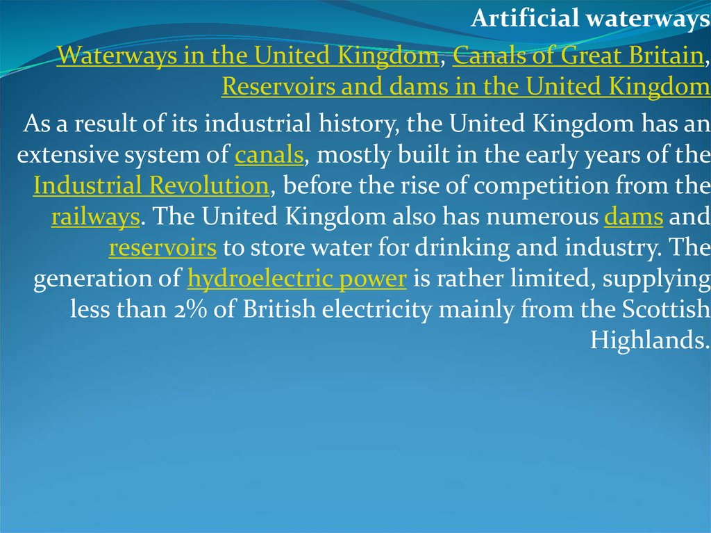
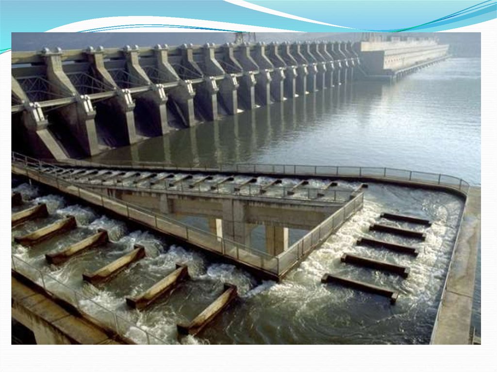
Artificial waterwaysWaterways in the United Kingdom, Canals of Great Britain,
Reservoirs and dams in the United Kingdom
As a result of its industrial history, the United Kingdom has an
extensive system of canals, mostly built in the early years of the
Industrial Revolution, before the rise of competition from the
railways. The United Kingdom also has numerous dams and
reservoirs to store water for drinking and industry. The
generation of hydroelectric power is rather limited, supplying
less than 2% of British electricity mainly from the Scottish
Highlands.
15.
Natural resourcesAgriculture is intensive, highly mechanised, and efficient by European standards, producing
about 60% of food needs with only 1% of the labour force. It contributes around 2% of GDP.
Around two thirds of production is devoted to livestock, one third to arable crops.
In 1993, it was estimated that land use was:
Arable land: 25 %
Permanent crops: 0 %
Permanent pastures: 46 %
Forests and Woodland: 10 %
Other: 19 %
Irrigated: 1,080 km²
The UK has a variety of natural resources including:
Geological: coal, petroleum, natural gas, limestone, chalk, gypsum, silica, rock salt, china
clay, iron ore, tin, silver, gold, lead.
Agricultural: arable land, wheat, barley, sheep
The UK has large coal, natural gas, and oil reserves; primary energy production accounts for
10% of GDP, one of the highest shares of any industrial nation. Due to the island location of
the UK, the country has great potential for generating electricity from wave power and tidal
power, although these have not yet been exploited on a commercial basis.
16.
Physical Geography17.
18.
19.
The United States is a country in the Western Hemisphere. Itconsists of forty-eight contiguous states in North America,
Alaska, a peninsula which forms the northwestern most part of
North America, and Hawaii, an archipelago in the Pacific
Ocean. There are several United States territories in the Pacific
and Caribbean. The term "United States", when used in the
geographical sense, means the continental United States,
Alaska, Hawaii, Puerto Rico, Guam, and the Virgin Islands of
the United States.[1] The country shares land borders with
Canada and Mexico and maritime (water) borders with Russia,
Cuba, and The Bahamas.
20.
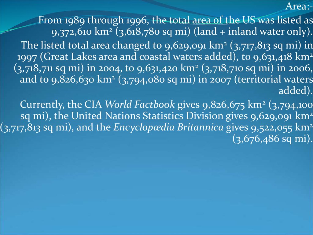
Area:From 1989 through 1996, the total area of the US was listed as9,372,610 km2 (3,618,780 sq mi) (land + inland water only).
The listed total area changed to 9,629,091 km2 (3,717,813 sq mi) in
1997 (Great Lakes area and coastal waters added), to 9,631,418 km2
(3,718,711 sq mi) in 2004, to 9,631,420 km2 (3,718,710 sq mi) in 2006,
and to 9,826,630 km2 (3,794,080 sq mi) in 2007 (territorial waters
added).
Currently, the CIA World Factbook gives 9,826,675 km2 (3,794,100
sq mi), the United Nations Statistics Division gives 9,629,091 km2
(3,717,813 sq mi), and the Encyclopædia Britannica gives 9,522,055 km2
(3,676,486 sq mi).
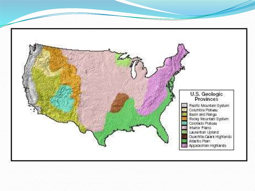
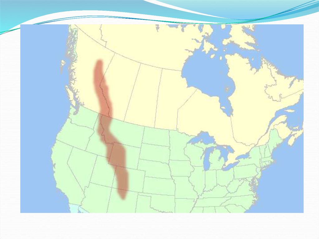
21. Landforms
The U.S. and Canada have several major mountainranges:
The Rocky Mountains
B. The Appalachian Mountains
C. Pacific Coastal Ranges
A.
22. The Rocky Mountains
The Rocky Mountains extend about 3,000 miles fromAlaska south to New Mexico. They are younger and
taller than the Appalachian Mountains. The
Continental Divide is the line of highest points in the
Rockies that marks the separation of rivers flowing
eastward and westward.
23.
24. The Appalachian Mountains
The Appalachian Mountains extend about 1,600 milesnorth to south from Newfoundland in Canada to
Alabama.
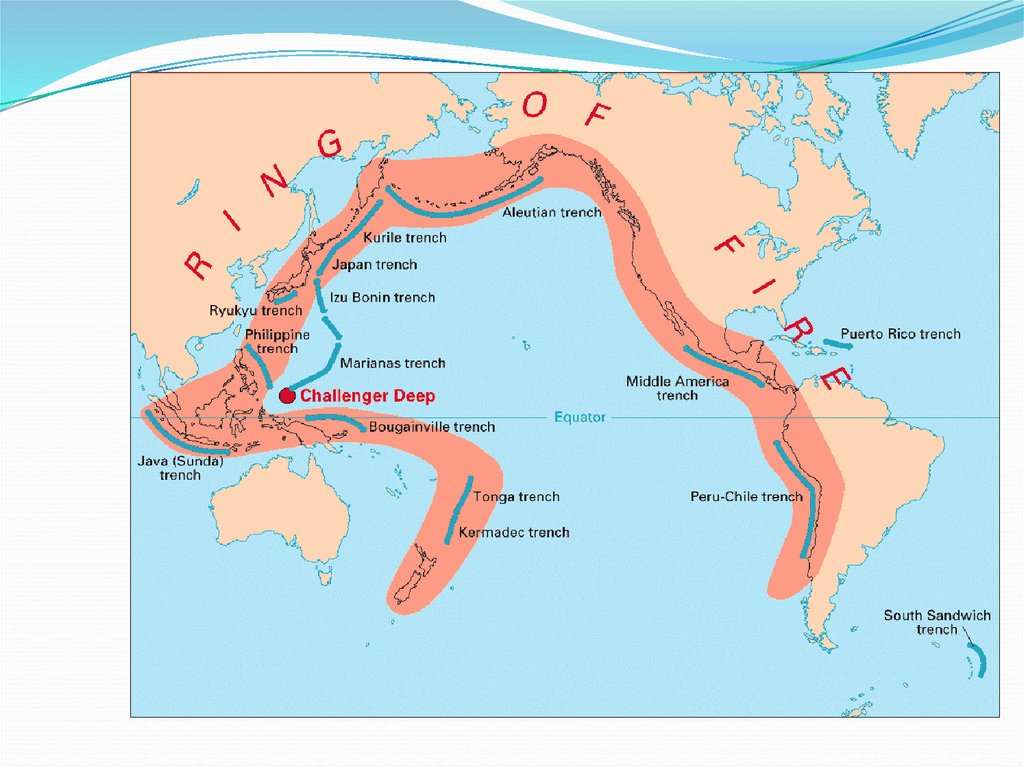
25. Pacific Coastal Ranges
A series of small mountain rangesstretch from southern California to Washington.
These ranges are low in elevation and right on the
coast. They make the coastline rugged and steep.
This area is also on the Ring of Fire and has many
active and dormant volcanoes. Earthquakes are
common in this area.
26.
27. Other Landforms
The Canadian ShieldB. Interior Lowlands
C. Atlantic and Gulf Coastal Plains
D. Basin and Range
E. Great Plains
F. Grand Canyon
A.
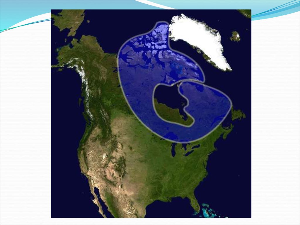
28. Canadian Shield
The Canadian Shield is a rocky, mainly flat areaaround Hudson Bay.
29.
30. Interior Lowlands
An area that spreads from the Appalachian Mountainsto the Mississippi River. This area is mostly flat with
rolling hills.
31. Arctic and Gulf Coastal Plains
These are flat areas that stretch along the Gulf ofMexico in the south and the Arctic Ocean in the north.
The Arctic Coastal Plain is tundra.
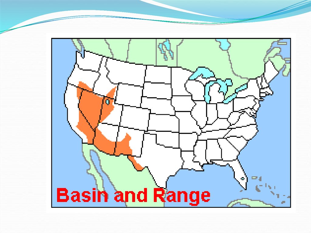
32. Basin and Range
This area is mostly in Nevada and it consists of rockyoutcroppings of rock and large depressions.
33.
34. Great Plains
A largely treeless flat area that extends from Canadadown to Mexico. The soil is very fertile and good for
farming but the climate can be harsh with cold winters
and hot summers. This area also gets many tornadoes.
35.
36. Grand Canyon
The Grand Canyon was formed by water erosionfrom the Colorado River. The canyon is 277 miles
long and ranges in width from 4 to 18 miles. Most
of the canyon is in Grand Canyon National Park in
Arizona.
See the Grand Canyon skywalk at youtube!
37.
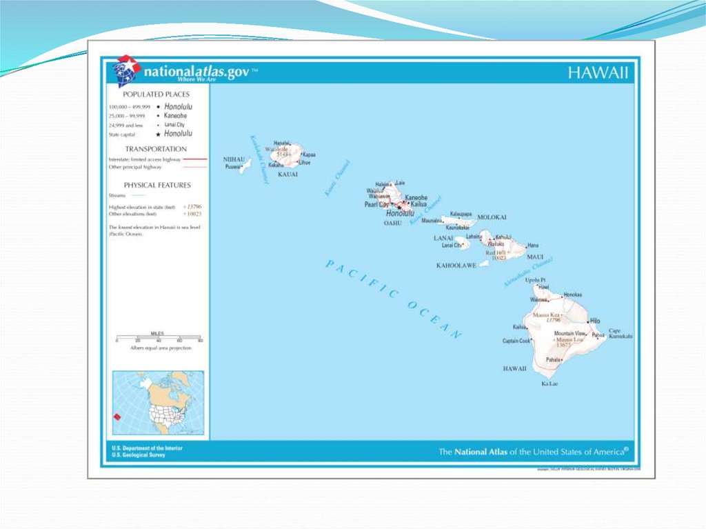
38. Groups of Islands
A. Hawaiian archipelago - A group of 19 islands andislets in the Pacific Ocean that formed over a
hotspot in the earth’s crust. The largest island,
Hawaii, has an active volcano.
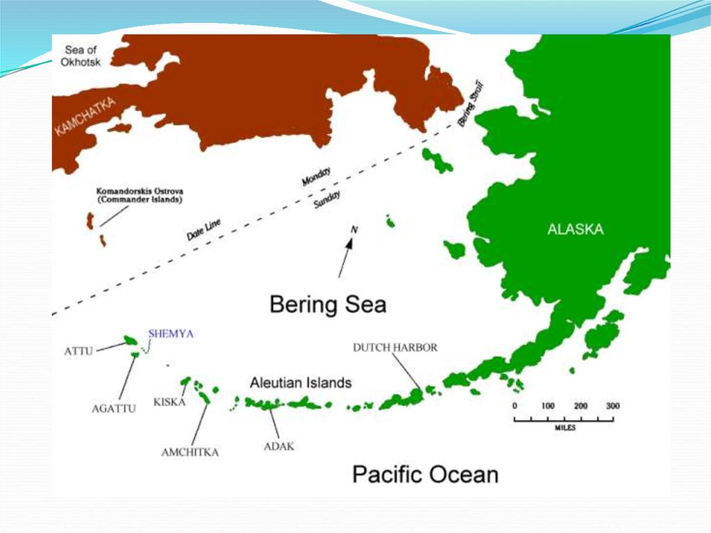
B. Aleutian Islands - A chain of over 300 small
volcanic islands that extend from Alaska to
Russia.
39.
40.
41. Rivers
Some major rivers in the United States are:A. Mississippi
B. St. Lawrence
C. Colorado
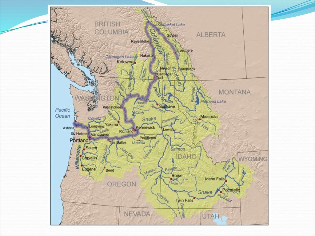
D. Columbia
E. Rio Grande
42. Mississippi River
The Mississippi River is the second longest river in theUnited States with a length of 2,340 miles. The river is
an important transportation route from the grain
producing states of middle America to the Gulf of
Mexico.
43.
44. St. Lawrence River
The St. Lawrence River connects the Great Lakes to theAtlantic Ocean. The river has a system of locks that
allow large ships to transport loads of minerals and
goods. Part of the river serves as the boarder between
Canada and the United States.
45.
46.
47.
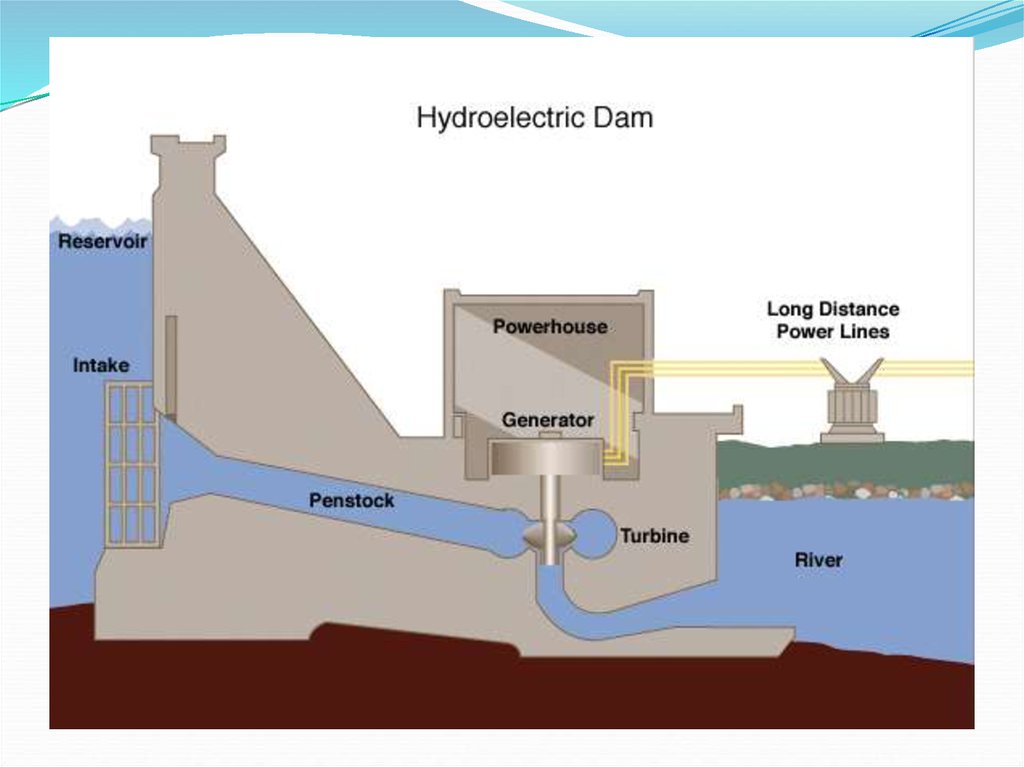
48. Colorado River
The Colorado River flows from Colorado to the Gulf ofCalifornia. The river formed the Grand Canyon by
erosion and it is an important source of fresh water in
an arid region. The Hoover Dam on the river provides
electricity for Los Angeles.
49.
50.
51.
52. Other Water Features
A.B.
C.
D.
E.
F.
Some other important water features are:
Gulf of Mexico
Great Lakes
Arctic Ocean
Pacific Ocean
Atlantic Ocean
Hudson Bay
53. Climate
Canada and the United States are in the middle andhigh latitudes. The most common climates are:
A. Humid Subtropical and Continental
B. Semiarid and Arid
C. Marine West Coast and Mediterranean
D. Tundra and Icecap
54. Climate
Most of the Eastern United States is humidsubtropical. This climate zone has a mild winter and
hot humid summers. The Northern states are humid
continental. They have much colder winters but the
summers can still be hot and uncomfortable.
55.
The tundra is a flat treeless plain with lichens, shrubs,and some flowers.
56.
The taiga is a coniferous forest that grows in subarcticclimates. Only coniferous trees grow because of the
Lack of sunlight in the wintertime.