
Similar presentations:


")

ВТ№1зан3 на англ
1. ВОЕННАЯ КАФЕДРА
2.
Academic discipline"Military topography"
Topic 1: "Orientation on the terrain without a map and
movement according to a given azimuth«
Lesson 3: "Movement along a given azimuth"
2
3.
Military topographyEducational issues:
1. Magnetic azimuth. Determining the sides of the
horizon in various ways on the ground.
2. Determining the direction of movement along a
given route.
3. Movement by azimuth. Bypass obstacles.
3
4.
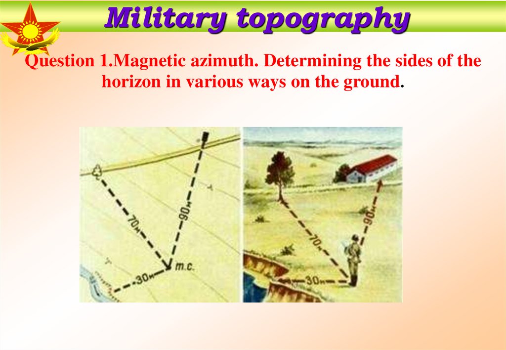
Military topographyQuestion 1.Magnetic azimuth. Determining the sides of the
horizon in various ways on the ground.
5.
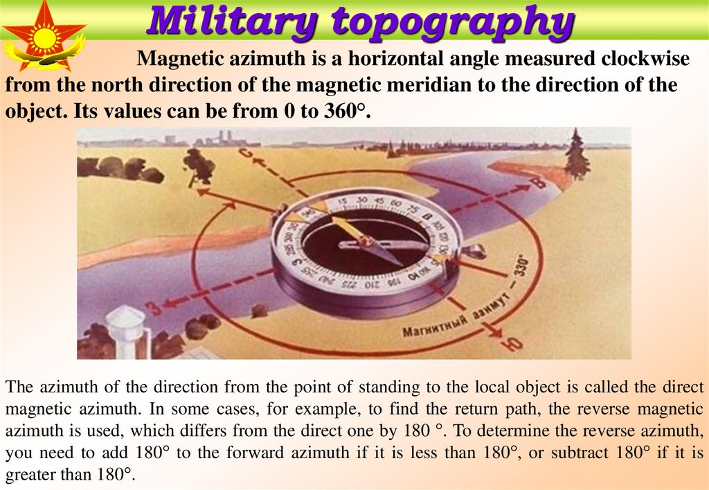
Military topographyMagnetic azimuth is a horizontal angle measured clockwise
from the north direction of the magnetic meridian to the direction of the
object. Its values can be from 0 to 360°.
The azimuth of the direction from the point of standing to the local object is called the direct
magnetic azimuth. In some cases, for example, to find the return path, the reverse magnetic
azimuth is used, which differs from the direct one by 180 °. To determine the reverse azimuth,
you need to add 180° to the forward azimuth if it is less than 180°, or subtract 180° if it is
greater than 180°.
6.
Military topographyDetermination of directions to the sides of the horizon by celestial bodies.
By the Sun In the northern hemisphere , the places of sunrise and sunset
according to the seasons are as follows:- in winter, the sun rises in the southeast and sets
in the southwest;- in summer, the sun rises in the northeast and sets in the northwest;In
spring and autumn, the sun rises in the east and sets in the west.
The sun is approximately at 7.00 in the east,
t 13.00 - in the south,
at 19.00 - in the west.
The position of the Sun at these hours will indicate the directions to the east, south and
west, respectively.
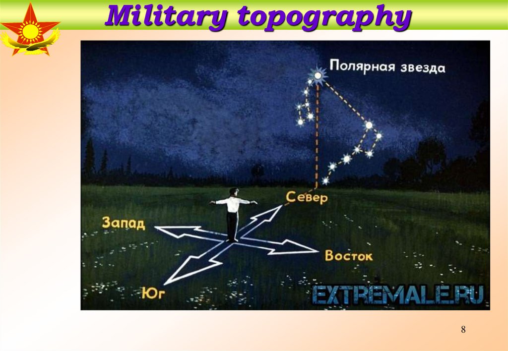
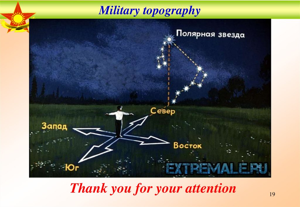
By the Polar Star The north star is always in the north. To find the North Star, you
must first find the constellation Ursa Major, resembling a bucket made up of seven fairly
bright stars. Then, through the two rightmost stars of the Big Dipper, mentally draw a line
on which to postpone the distance between these extreme stars five times, and then at the
end of this line we will find the Polar Star, which, in turn, is located in the tail of another
constellation called the Little Dipper. If we face the Polar Star, we will get a direction to the
north (Fig. 6.19).
6
7.
Military topographyBy the Polar StarThe north star is always in the north. To find the North
Star, you must first find the constellation Ursa Major, resembling a bucket made up
of seven fairly bright stars. Then, through the two rightmost stars of the Big Dipper,
mentally draw a line on which to postpone the distance between these extreme stars
five times, and then at the end of this line we will find the Polar Star, which, in turn,
is located in the tail of another constellation called the Little Dipper. If we face the
Polar Star, we will get a direction to the north (Fig. 6.19).
7
8.
Military topography8
9.
Military topography9
10.
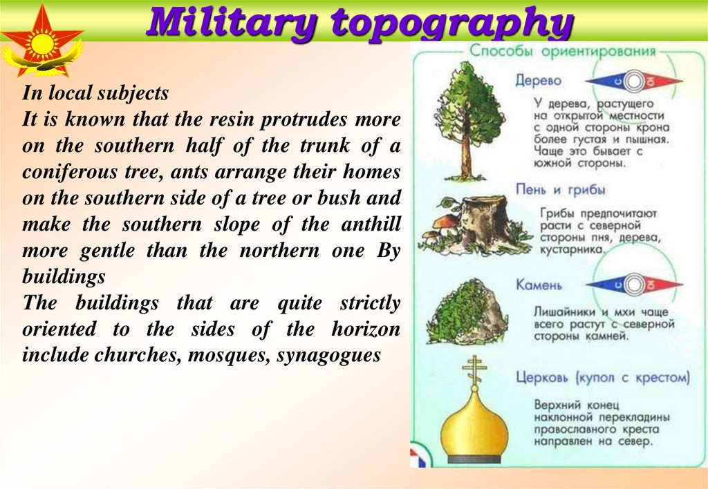
Military topographyIn local subjects
It is known that the resin protrudes more
on the southern half of the trunk of a
coniferous tree, ants arrange their homes
on the southern side of a tree or bush and
make the southern slope of the anthill
more gentle than the northern one By
buildings
The buildings that are quite strictly
oriented to the sides of the horizon
include churches, mosques, synagogues
10
11.
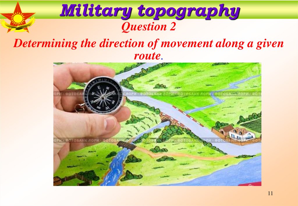
Military topographyQuestion 2
Determining the direction of movement along a given
route.
11
12.
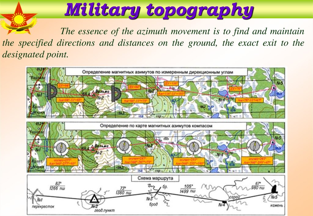
Military topographyThe essence of the azimuth movement is to find and maintain
the specified directions and distances on the ground, the exact exit to the
designated point.
12
13.
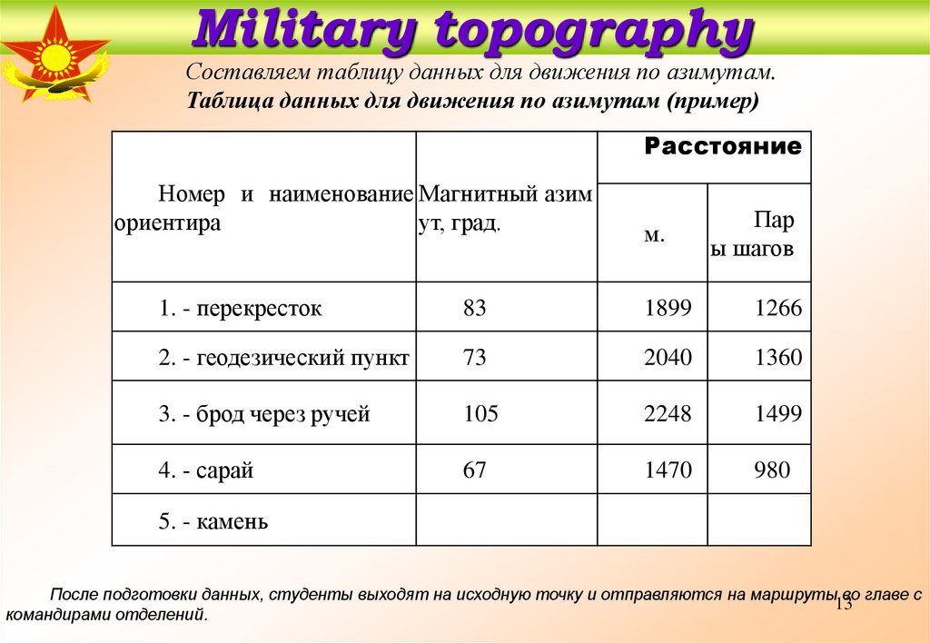
Military topographyСоставляем таблицу данных для движения по азимутам.
Таблица данных для движения по азимутам (пример)
Расстояние
Номер и наименование Магнитный азим
ориентира
ут, град.
м.
Пар
ы шагов
1. - перекресток
83
1899
1266
2. - геодезический пункт
73
2040
1360
3. - брод через ручей
105
2248
1499
4. - сарай
67
1470
980
5. - камень
После подготовки данных, студенты выходят на исходную точку и отправляются на маршруты во главе с
13
командирами отделений.
14.
Military topographyQuestion 3
Movement by azimuth. Avoiding obstacles
14
15.
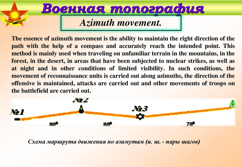
Военная топографияAzimuth movement.
The essence of azimuth movement is the ability to maintain the right direction of the
path with the help of a compass and accurately reach the intended point. This
method is mainly used when traveling on unfamiliar terrain in the mountains, in the
forest, in the desert, in areas that have been subjected to nuclear strikes, as well as
at night and in other conditions of limited visibility. In such conditions, the
movement of reconnaissance units is carried out along azimuths, the direction of the
offensive is maintained, attacks are carried out and other movements of troops on
the battlefield are carried out.
Схема маршрута движения по азимутам (и. ш. - пары шагов)
16.
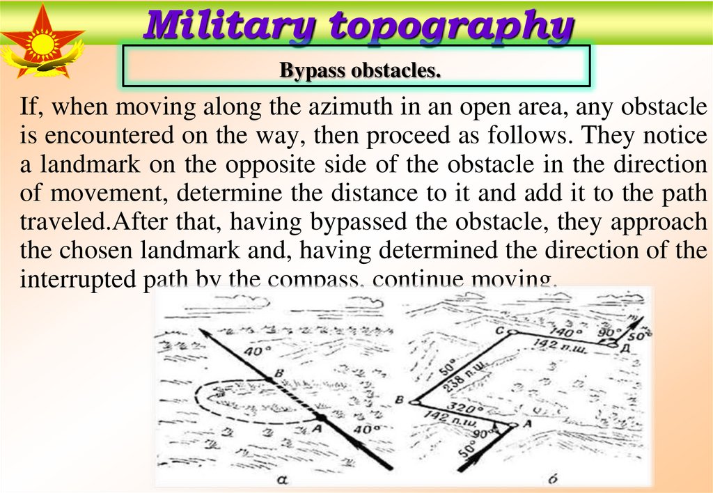
Military topographyBypass obstacles.
If, when moving along the azimuth in an open area, any obstacle
is encountered on the way, then proceed as follows. They notice
a landmark on the opposite side of the obstacle in the direction
of movement, determine the distance to it and add it to the path
traveled.After that, having bypassed the obstacle, they approach
the chosen landmark and, having determined the direction of the
interrupted path by the compass, continue moving.
17.
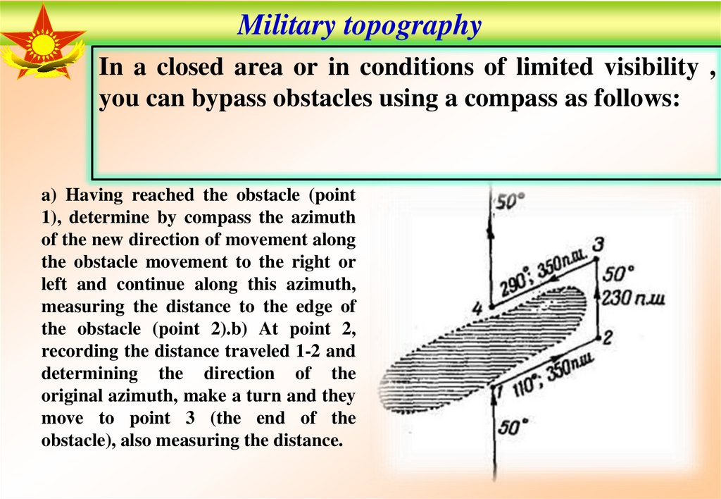
Military topographyIn a closed area or in conditions of limited visibility ,
you can bypass obstacles using a compass as follows:
a) Having reached the obstacle (point
1), determine by compass the azimuth
of the new direction of movement along
the obstacle movement to the right or
left and continue along this azimuth,
measuring the distance to the edge of
the obstacle (point 2).b) At point 2,
recording the distance traveled 1-2 and
determining the direction of the
original azimuth, make a turn and they
move to point 3 (the end of the
obstacle), also measuring the distance.
18.
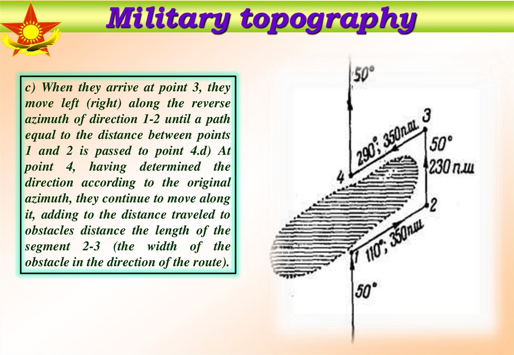
Military topographyc) When they arrive at point 3, they
move left (right) along the reverse
azimuth of direction 1-2 until a path
equal to the distance between points
1 and 2 is passed to point 4.d) At
point 4, having determined the
direction according to the original
azimuth, they continue to move along
it, adding to the distance traveled to
obstacles distance the length of the
segment 2-3 (the width of the
obstacle in the direction of the route).
19.
Military topographyThank you for your attention
19