


 english
 geography
Similar presentations:


Urban Planning Kazakhstan. City planning and Urbanization
1. Urban planning
URBANPLANNING
KAZAKHSTAN, City planning and Urbanization
Student: Mukhammed Aleumet Askar
2. Central Asia: Core and Periphery
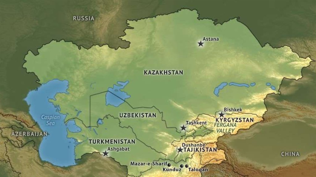
CENTRAL ASIA:CORE AND PERIPHERY
Central Asia is, by its most common definition, those five “stans” that
were formerly Soviet republics: Kazakhstan, Kyrgyzstan, Tajikistan,
Turkmenistan, and Uzbekistan.
Kazakhstan. From 1926 to 1989, the population of Kazakhstan
increased 2.7-fold - from 6 million to 16.5 million people. From the 1950s
through the 1980s, Kazakhstan’s population growth was mainly driven by
natural factors.
Kazakhstan is the world's largest landlocked country, and the ninth largest in
the world, with an area of 2,724,900 km².
Kazakhstan is the dominant nation of Central Asia economically, generating
60% of the region's GDP, primarily through its oil/gas industry.
3.
4. Industrial policy and spatial development
INDUSTRIAL POLICY AND SPATIALDEVELOPMENT
Urbanization in Kazakhstan was mainly driven by the creation of industrial
areas. In 1939 the country had 28 cities and 53 urban-type settlements; by 1945
their numbers had risen to 38 and 100, respectively. The scale of urbanization
continued to grow in the postwar period, resulting in 40 new cities.
By the early 1980s, the share of urban population in Karaganda,
Mangyshlak and Dzhezkazgan, reached 83-89% of total population, a very high
proportion compared with the rest of Central Asia.
Kazakhstan currently has 87 cities, of which two cities have national status
(Almaty and Astana); 40 are oblast-level cities , including 14 oblast centers; and 45
are district-level cities. The 16 oblast centers (including Almaty and Astana) are
home to 67% of Kazakhstan’s total urban population.
5.
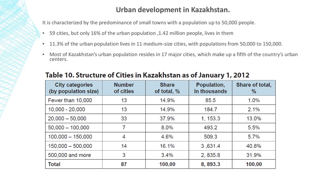
Urban development in Kazakhstan.It is characterized by the predominance of small towns with a population up to 50,000 people.
▪ 59 cities, but only 16% of the urban population ,1.42 million people, lives in them
▪ 11.3% of the urban population lives in 11 medium-size cities, with populations from 50,000 to 150,000.
▪ Most of Kazakhstan’s urban population resides in 17 major cities, which make up a fifth of the country’s urban
centers.
6.
7. Almaty the city of apples
ALMATY THE CITY OF APPLESAlmaty is the Old Capital
Almaty is a beautiful city perched among the mountains in Southern Kazakhstan. Its name comes
from the Kazakh word “alma” which means “apple” apple orchards have long surrounded the city.
Almaty is the largest city in Kazakhstan, with a population of 1,797,431 people, about 8% of the
country's total population. It served as capital of the Kazakh state in its various forms from 1929 to
1997.
From 1966 to 1971, 1,400,000 square meters of public and cooperative housing were built.
Annually, around 300,000 square meters of dwellings were under construction. The Soviet
government tried to diversify architectural forms to create a more varied cityscape. During this
period, many schools, hospitals, cultural, and entertainment facilities were constructed, including
Lenin's Palace, the Kazakhstan Hotel, and the "Medeo" sports complex.
8.
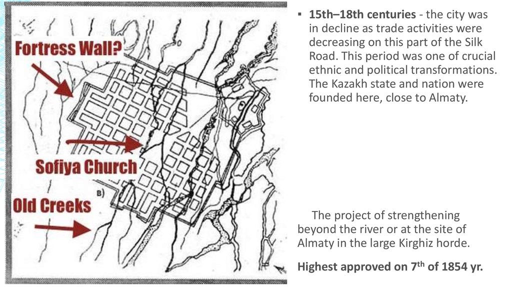
▪ 15th–18th centuries - the city wasin decline as trade activities were
decreasing on this part of the Silk
Road. This period was one of crucial
ethnic and political transformations.
The Kazakh state and nation were
founded here, close to Almaty.
The project of strengthening
beyond the river or at the site of
Almaty in the large Kirghiz horde.
Highest approved on 7th of 1854 yr.
9.
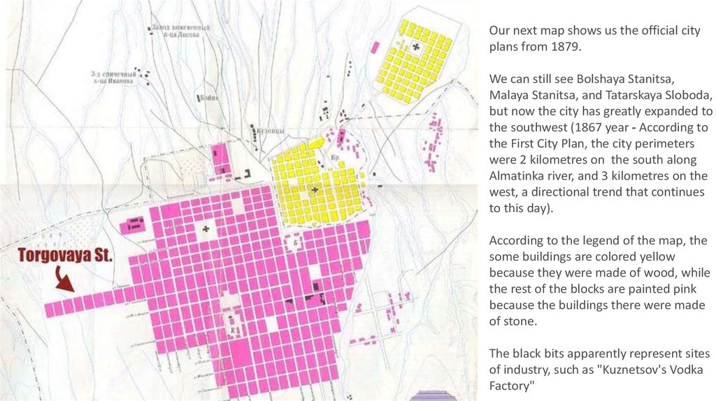
Our next map shows us the official cityplans from 1879.
We can still see Bolshaya Stanitsa,
Malaya Stanitsa, and Tatarskaya Sloboda,
but now the city has greatly expanded to
the southwest (1867 year - According to
the First City Plan, the city perimeters
were 2 kilometres on the south along
Almatinka river, and 3 kilometres on the
west, a directional trend that continues
to this day).
According to the legend of the map, the
some buildings are colored yellow
because they were made of wood, while
the rest of the blocks are painted pink
because the buildings there were made
of stone.
The black bits apparently represent sites
of industry, such as "Kuznetsov's Vodka
Factory"
10.
By year 1906 - thepopulation of the city had
grown to 27,000, two-thirds
of whom were Russians and
Ukrainians.
The points marked 16-21
show where famous military
figures like Mikhail Frunze
and Bagautdin Shagabutdinov
lived, but D.A. Furmanov's
home, number 21, is
somewhere off the map.
11.
Map of Verny, current Almaty, which was made in 1912.12.
1926 year - the construction ofthe Turkestan-Siberia
Railway that was a crucial
element of the future growth of
Kazakhstan, especially in the
east and southeast of the
region.
1929 year - The Russian
Imperial city of Verny has been
renamed Alma-Ata, and since it
has become the capital of the
Kazakh Soviet Socialist Republic.
1930 year - The Alma-Ata
airport was opened in, opening
up a direct connection from
Alma-Ata to Moscow.
1936 year - the Architecture
and Planning Bureau developed
a plan to enhance Alma-Ata as
the new cultural capital of the
Kazakh SSR. The plan was based
on the existing rectangular
system of districts.
13.
This map from 1937 is thefirst to show the city's
administrative divisions,
or raiony.
With names like Lenin
District, Stalin District, and
Frunze District, the exact
territorial units featured in
the map are a thing of the
past, but their
predecessors live on, with
eight modern-day raiony:
Medeusky, Almalinsky,
Bostandyksky, Auezovsky,
Alatausky, Zhetisuisky,
Turksibsky, and the
newest, announced just
this year, Nauryzbaisky.
14.
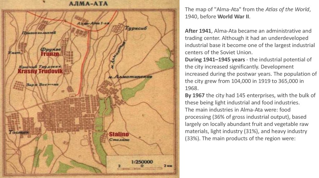
The map of "Alma-Ata" from the Atlas of the World,1940, before World War II.
After 1941, Alma-Ata became an administrative and
trading center. Although it had an underdeveloped
industrial base it become one of the largest industrial
centers of the Soviet Union.
During 1941–1945 years - the industrial potential of
the city increased significantly. Development
increased during the postwar years. The population of
the city grew from 104,000 in 1919 to 365,000 in
1968.
By 1967 the city had 145 enterprises, with the bulk of
these being light industrial and food industries.
The main industries in Alma-Ata were: food
processing (36% of gross industrial output), based
largely on locally abundant fruit and vegetable raw
materials, light industry (31%), and heavy industry
(33%). The main products of the region were:
15.
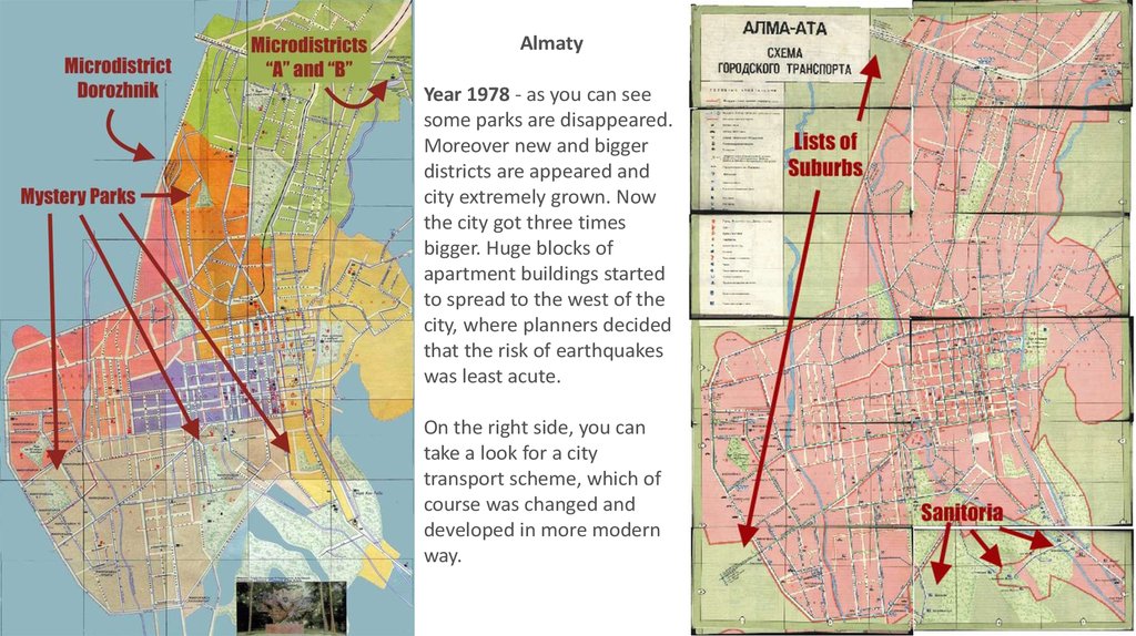
AlmatyYear 1978 - as you can see
some parks are disappeared.
Moreover new and bigger
districts are appeared and
city extremely grown. Now
the city got three times
bigger. Huge blocks of
apartment buildings started
to spread to the west of the
city, where planners decided
that the risk of earthquakes
was least acute.
On the right side, you can
take a look for a city
transport scheme, which of
course was changed and
developed in more modern
way.
16.
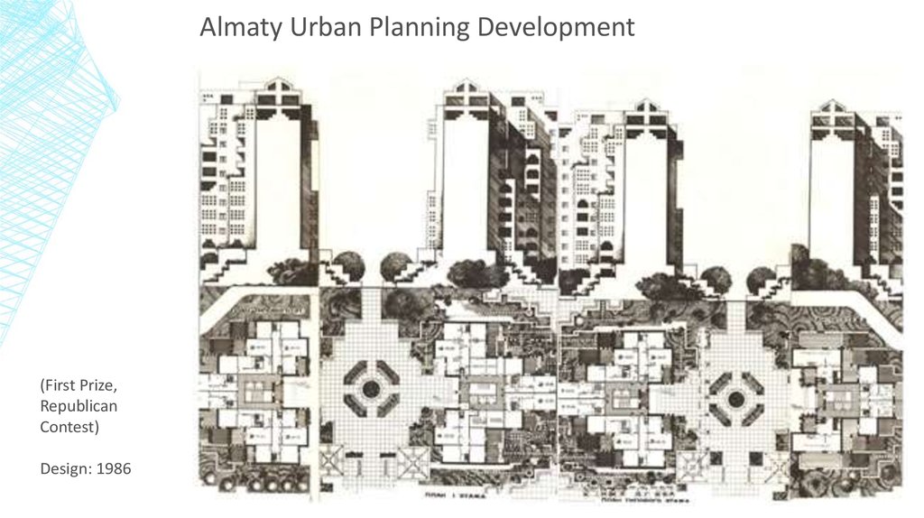
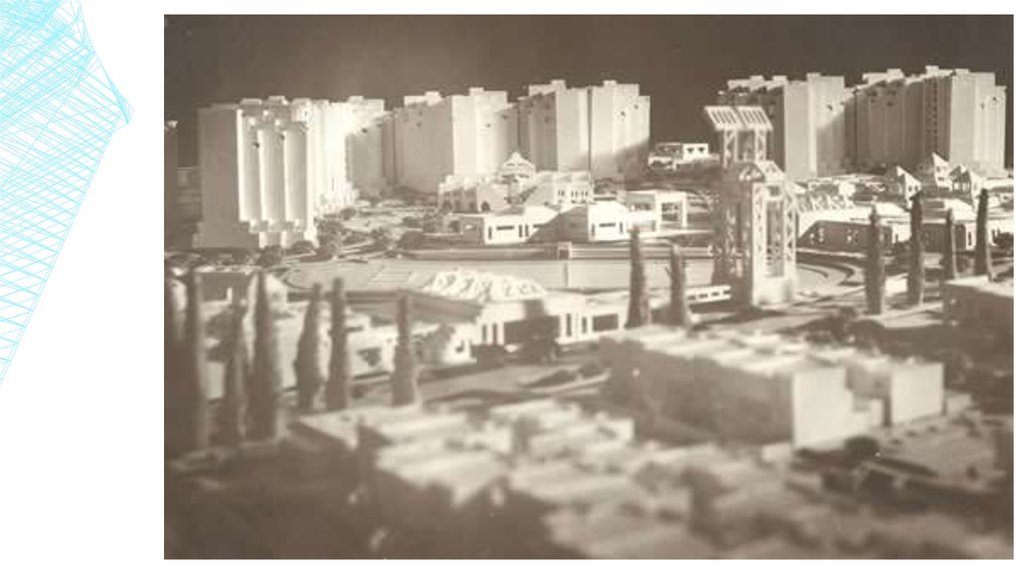
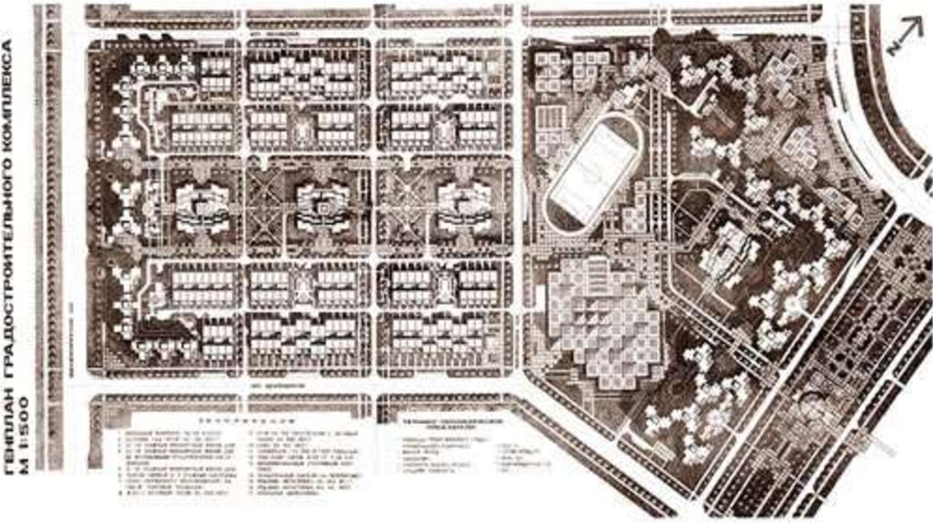
Almaty Urban Planning Development(First Prize,
Republican
Contest)
Design: 1986
17.
18.
19.
20.
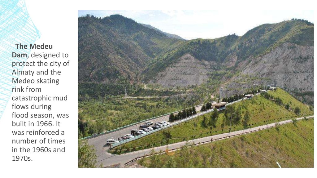
The MedeuDam, designed to
protect the city of
Almaty and the
Medeo skating
rink from
catastrophic mud
flows during
flood season, was
built in 1966. It
was reinforced a
number of times
in the 1960s and
1970s.
21.
“Medeo” sportcomplex
22. The multifunctional complex NURLY TAU
THE MULTIFUNCTIONAL COMPLEXNURLY TAU
The multifunctional complex NURLY TAU is an architectural focus of the administrative centers of Almaty and
is the one of the largest social centers in Kazakhstan. The unique architecture of the complex in the Hi-tech
style repeats the shape of the Zaily Alatau Mountain.
To achieve such an effect,
the hardened light-reflective
special glass with the grayblue color was used.
NURLY TAU was constructed as a “city
inside the city”.
23.
24. Revitalization and rehabilitation needs, preservation of monuments The Zenkov’s Cathedral in Almaty
REVITALIZATION AND REHABILITATION NEEDS,PRESERVATION OF MONUMENTS
THE ZENKOV’S CATHEDRAL IN ALMATY
This orthodox cathedral is deservingly considered as one of the most interesting architectural
monuments in Almaty. The wooden building, towering at a height of 56 meters, was constructed in the
beginning of the XXth century.
Built under the guidance of engineer
Andre Zenkov, without the use of a single
nail, it was one of the few pre-Soviet
buildings to survive the earthquakes of
1910 with nothing more than a bent
spire.The cathedral has six spires made of
iron, and its internal fresco was created
by the artist, Nikolay Khlydov. The
cathedral is in the centre of Panfilov Park,
named after the 28th Panfilov Battalion,
including the guardsmen of the 316th
shooting division, all of whom served
with distinction during the defense of
Moscow in 1941/1942.
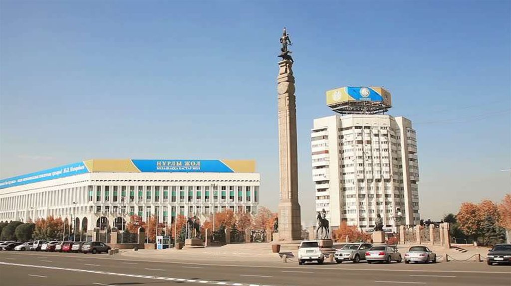
25. Independence Monument
INDEPENDENCEMONUMENT
Independence Monument of Kazakhstan is a
monument on the central square (Republic Square)
Almaty, the main motive of which is the image of
the Golden Man. Along with Bayterek, it is a symbol
of modern Kazakhstan.
Truly unique construction, decorating the Republic
square, was presented the author's creative team
led by Shota Valikhanov. The majestic Golden Man,
soaring into the dazzling sky of Almaty manages to
tame the winged snow leopard, and thus the
history of ancient Kazakh land is presented around
the front of the viewer...
26.
27. Park of 28 Panfilov Guardsmen
PARK OF 28 PANFILOV GUARDSMENPark of Heroes 28-Panfilov Guardsmen, located in the heart of Almaty city.
The park was planted on 8 May, 1975 on the
eve of 30th anniversary of the victory of Soviet
people in the Great Patriotic War. It consists of
three arrangements that complement each
other.
• «Oath» (left side) - is dedicated to the
young fighters for Soviet power in
Kazakhstan.
• «Act of Bravery» - captured images of the
heroes Panfilov Guardsmen, Russians,
Kazakhs, Ukrainians, symbolizing the
international nature of the heroic feat of
Soviet people in November 1941 near
Moscow.
• The right track «Trumping the Glory», gives
the entire memorial optimistic sound, its
images represent hymn of triumphant life.
the battle for Moscow.
28. Almaty Central Mosque
ALMATY CENTRALMOSQUE
The central mosque of Almaty city,
opened in 1999, is one of the
largest mosques of Kazakhstan.
A capacity of the grand construction
is up to 7 thousand visitors. The
majestic building is finished by
marble and the colour tiles, which
was executed in the Kazakh national
motives. The mosque is crowned by
a blue dome a diameter of 20
meters and a height of 36 m. Height
of the highest minaret is 47 metres.
In 2000 the big dome was
decorated with from the Koran in
calligraphical execution of Turkish
masters. The Architects are
Bajmagambetov and Sharapiev.
29.
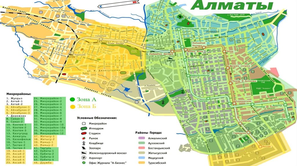
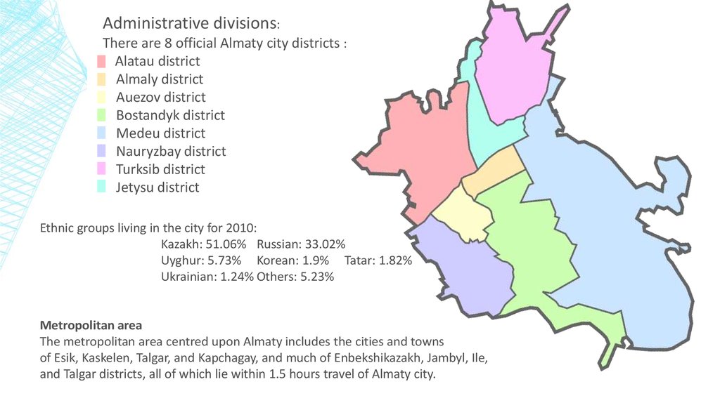
Administrative divisions:There are 8 official Almaty city districts :
Alatau district
Almaly district
Auezov district
Bostandyk district
Medeu district
Nauryzbay district
Turksib district
Jetysu district
Ethnic groups living in the city for 2010:
Kazakh: 51.06% Russian: 33.02%
Uyghur: 5.73% Korean: 1.9% Tatar: 1.82%
Ukrainian: 1.24% Others: 5.23%
Metropolitan area
The metropolitan area centred upon Almaty includes the cities and towns
of Esik, Kaskelen, Talgar, and Kapchagay, and much of Enbekshikazakh, Jambyl, Ile,
and Talgar districts, all of which lie within 1.5 hours travel of Almaty city.
30. Almaty growth and development
ALMATY GROWTH AND DEVELOPMENTIn 1998 - The new General Plan of Almaty for 2030 was developed. It is
intended to create ecologically safe, secure, and socially comfortable living
conditions in the city.
The main objective is to promote Almaty's image as a garden-city. It proposes
continued multi-storied and single-housing development, reorganization of
industrial districts or territories, improving transport infrastructure, and
expanding the Almaty Metro.
Also Almaty has developed a major problem with air pollution,
nowadays Almaty is the 9th most polluted city in the world.
In 1995 - particulate emissions, then mostly from the city's thermal power
station, exceeded Kazakh and EU standards by over 20 times.
31. Public transport systems alamaty
PUBLIC TRANSPORT SYSTEMS ALAMATYAs we live in one of the biggest cities in our country there are lots of traffic jams on the street. To
get somewhere as quickly as possible it is not effective to go on foot always and catching taxi is really
expensive. So there are many types of transport for you as trams, subway, trolleybuses and buses.
▪ The bus is the main type of public transport in our city which the majority of city residents use daily.
Today 160 bus routes exist in Almaty, some of them link the city with the settlements located nearby.
Besides, some of the buses (approx. 800 units) were transferred to the compressed natural gas.
▪ The trolleybus network of Almaty city consists of 8 routes which connect the west, the east and the
south of the city to railway stations "Almaty-1" and "Almaty-2".
(On the next picture you can clearly a simple map system of bus and trolleybus network around the whole city)If you
follow to this link (https://alatransit.kz/en), you can see a separate for each bus and trolleybus schemes.
32.
33. Trams
TRAMS▪ The movement of the trams in Almaty was suspended on 31st of 2015.
Tram infrastructure and the tracks condition are in a critical condition and
demand repair.
▪ Since 2009 Regardless of the decision on old tram tracks, the high-speed
light rail tram (LRT) project has been considered in Almaty.
34. Trams
TRAMS▪ Since 2013 a new project phase has begun at the request of Almaty city
Akimat, with assistance of the PROON-GEF Project "City of Almaty Sustainable
Transport" and the European Bank of Reconstruction and Development
▪ The project includes construction of the LRT line 22.9 km long. The forecast
capacity will be 77–106 thousand passengers a day.
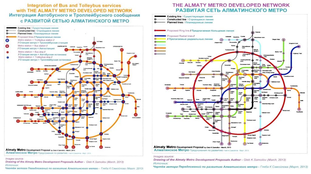
35. metro
METROThe metro of Almaty is the newest type of public transport in the city. The first stage
with total length of 8.6 km was put in operation on 1 December 2011. It includes seven stations:
«Raimbek batyr», "Zhibek zholy", "Almaly", "Abai", "Baikonyr", «Auezov drama theatre» and
"Alatau". On 18 April 2015 two more stations "Sairan" and "Moscow" were opened.
The Metro will expand in the future. Upon completion, the metro system is planned to total 45
kilometres in length.
36.
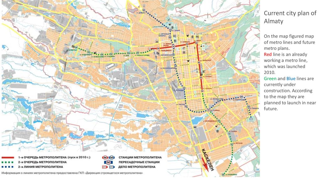
Current city plan ofAlmaty
On the map figured map
of metro lines and future
metro plans.
Red line is an already
working a metro line,
which was launched
2010.
Green and Blue lines are
currently under
construction. According
to the map they are
planned to launch in near
future.
37.
38.
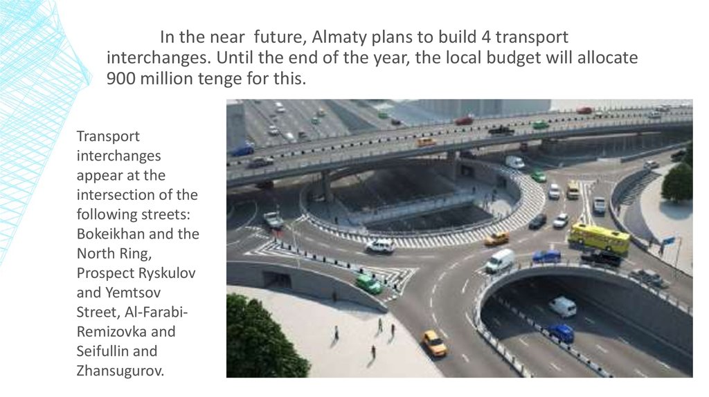
In the near future, Almaty plans to build 4 transportinterchanges. Until the end of the year, the local budget will allocate
900 million tenge for this.
Transport
interchanges
appear at the
intersection of the
following streets:
Bokeikhan and the
North Ring,
Prospect Ryskulov
and Yemtsov
Street, Al-FarabiRemizovka and
Seifullin and
Zhansugurov.
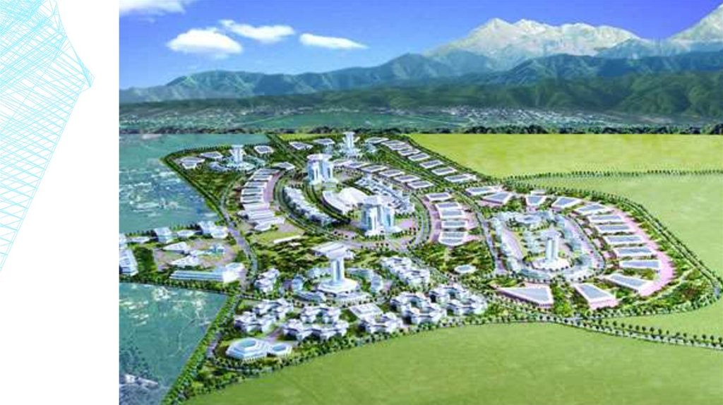
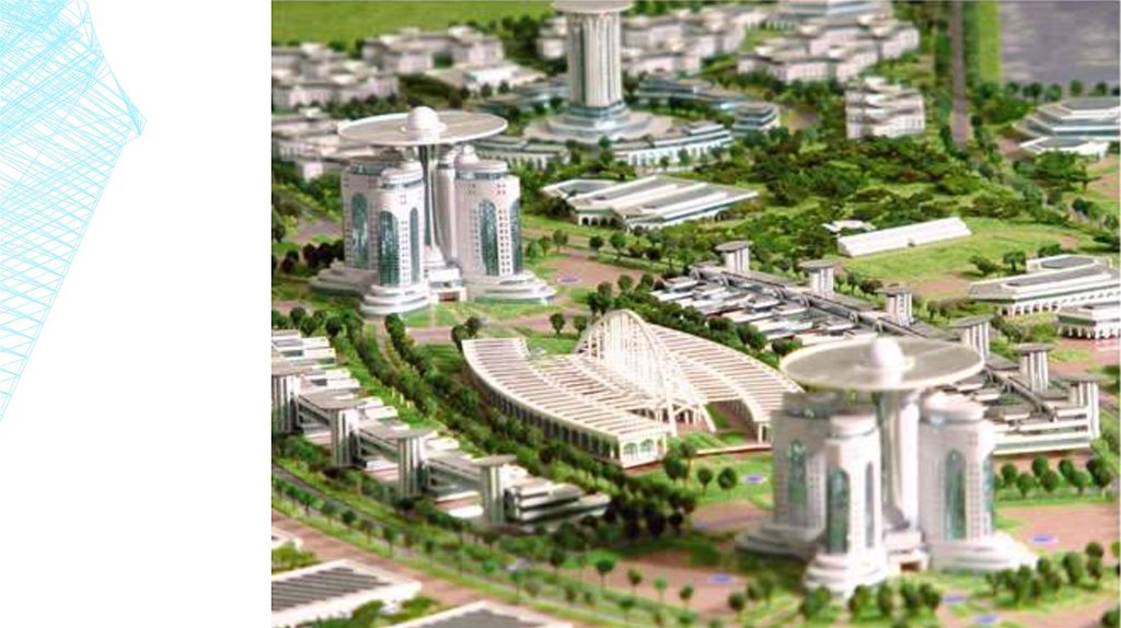
39. Future major constructions
FUTURE MAJOR CONSTRUCTIONSUniversity of science
40.
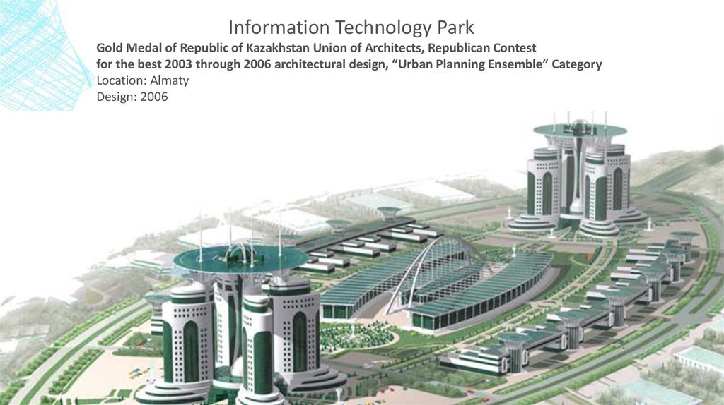
Information Technology ParkGold Medal of Republic of Kazakhstan Union of Architects, Republican Contest
for the best 2003 through 2006 architectural design, “Urban Planning Ensemble” Category
Location: Almaty
Design: 2006
41.
42.
43. Expending the city project
EXPENDING THE CITY PROJECTWith considering of the global context and the modern tendency of the development, the main task of
Almaty is to stay and be one of the drivers of the economic growth of Kazakhstan, supplying the
resident’s high standard of living.
Almaty must be the key factor
of ambitious aim’s
achievement in entering of
Kazakhstan in the list of 30
competitive countries of the
world to 2050 years set in the
strategy«Kazakhstan–2050»
by Kazakhstan Republic’s
President, Elbasy,(The Head of
the State) Nursultan
Abishevich Nazarbayev.
44. Conclusion
CONCLUSIONIf we take a look back for 20 years, the process of urbanization and urban
development has been a difficult for the Central Asian countries. This was due
primarily to the consequences of Soviet urbanization.
Further on, most of the countries the transition period has deepened divisions
between regions in terms of social and economic development, also widened the
gaps between rural and urban populations at last magnified the problem of small
and medium-size towns.
The solution for the urban issues will be the dynamic processes of urbanization in
Kazakhstan in the medium and long term will create new opportunities for industrial
and agricultural development, forming megacities of regional and interregional
scope, and improving the quality of urban life.
45. References
REFERENCESUrban, Social, Rural and Resilient Global Practice (GPSURR)
United Nations: Economic and Social Commission for Asia and the Pacific (ESCAP)“Urbanization in Central Asia:
Challenges, Issues and Prospects”, Tashkent 2013
National Economy of Kazakhstan in 1983. p. 5. Quoted by Iskakov. The cities of Kazakhstan: Issues of Socioeconomic
Development. Alma-Ata, Nauka, 1985 (Народное хозяйство Казахстана в 1983 г. с. 5. Цитируется по Искаков У.М.
Города Казахстана: проблемы социально-экономического развития. – Алма-Ата; Наука, 1985)
Kazakhstan Statistics Agency. 2009
Websides:
http://www.kazgor.com/
http://astana.gov.kz/en/modules/material/47
https://astanatimes.com/2015/12/astana-architecture-and-city-building-management-chief-highlights-capitals-plan-for-harmoniousarchitectural-development/
https://www.oecd-ilibrary.org/urban-rural-and-regional-development/oecd-urban-policy-reviews-kazakhstan/governing-urbanisationin-kazakhstan_9789264268852-7-en
http://citymaps4.tripod.com/Kazahstan/Almaty/index.html