


 geography
Similar presentations:


")
The United States of America
1. The United States of America
2.
General informationThe United States of America is a country located in North
America.
Its total area is 9,518,900 km² (the fourth largest in the world by
land area).
The population exceeds 347 million people (the third largest
globally).
The capital city is Washington, D.C.
Administratively, the country consists of 50 states and the federal
district of Columbia, along with several overseas territories under U.S.
jurisdiction. The United States was founded in 1776 when thirteen British
colonies declared their independence and united to form a new nation.
3. Introduction in the history
The territory of present-day United States was first explored by theEnglish navigator John Cabot in 1497.
The first permanent European settlements in what is now the U.S.
were established by the Spanish in Florida (St. Augustine in 1565) and by
the English in Virginia (Jamestown in 1607).
By the 1770s, thirteen British colonies had been established in the
region.
On July 4, 1776, these colonies declared their independence from
British rule and became known as the United States of America.
4. THE U.S. CONSTITUTION
The U.S. Constitution was drafted and adoptedby the Constitutional Convention held in Philadelphia
from May to September 1787. However, the original
text of the Constitution did not include provisions
guaranteeing citizens' political, personal, and
procedural rights.
In 1789, the Bill of Rights — the first ten
amendments to the Constitution — was introduced,
establishing fundamental political, personal, and
legal rights for citizens. This was largely due to public
pressure and advocacy by democratically minded
lawmakers.
The U.S. Constitution officially entered into force
on March 4, 1789.
5. SIGNING OF THE U.S. CONSTITUTION
6. POLITICAL SYSTEM OF THE COUNTRY
The United States is a federal republic composed of 50 states. In addition, theDistrict of Columbia is a separate federal district that hosts the nation’s capital,
Washington, D.C.
The head of state is the President, elected for a four-year term.
The highest legislative body is Congress, consisting of two chambers: the House
of Representatives and the Senate.
Each state has its own constitution, legislative and executive branches, an
elected governor, and its own official symbols and emblems.
7. THE CAPITAL OF THE UNITED STATES - WASHINGTON, D.C.
THE CAPITAL OF THE UNITED STATES WASHINGTON, D.C.8. TERRITORY AND BORDERS
The country consists of three mainThe United States ranks fourth in the world by land
parts:
area, covering approximately 9.4 million square
1. The contiguous United States (also kilometers.
called the "Lower 48")—48 connected
states forming a large, roughly rectangular
landmass stretching about 4,700 km from
east to west and 3,000 km from north to
south.
2. Alaska, located in the northwest
corner of North America.
3. The Hawaiian Islands, situated in
the Pacific Ocean.
The U.S. shares land borders with
Canada to the north and Mexico to the
south.
9. POPULATION
The United States ranks third in the world by population—approximately347 million people (after China and India).
The country’s annual population increase is about 2–2.5 million, which
supports a pattern of population replacement. However, the era when the U.S.,
as a young nation, ranked among the world leaders in natural population
growth has long passed.
Roughly 40% of this population growth comes from immigration. Since
the early 19th century, around 60 million people from nearly 70 countries have
immigrated to the United States. Even today, despite various restrictions, the
country admits approximately 1 million legal immigrants annually.
10. ETHNIC COMPOSITION OF THE POPULATION
The modern American nation is the result of ethnic mixing and blending of settlers fromdifferent parts of the world, especially from Europe and Africa.
Today, more than 100 ethnic groups live in the United States.
The three main ethnic groups are:
• Americans of the United States (about 90% of the total population), or simply Americans—
that is, descendants of immigrants of various nationalities for whom English is now their
native language. Of these, 80% are of European origin; 12% are African Americans; nearly
4% are of Hispanic or Latino origin; and almost 4% are of Asian or Pacific Islander descent.
• Recent immigrant groups who have moved to the U.S. relatively recently and have not yet
fully integrated into American society.
• Indigenous residents (about 1% of the country’s population)—Native Americans, Aleuts, and
Inuit.
An important consequence of current migration trends is that 14% of the population does not
speak English.
11. Native Americans – the Indigenous People of the United States
12. Aleuts – the Indigenous People of the Aleutian Islands and Alaska
13. Inuit – the Indigenous People of the Northern United States
14. A country of cities
76% of the population lives in urban areas.The United States has nearly 9,000 cities, and population distribution is largely shaped by the
geography and layout of these cities.
The North American city model:
- Relatively young in origin.
- Characterized by a clear rectangular grid pattern.
- Features a central business district — “downtown” — where government offices, banks,
media outlets, and service industries are concentrated.
- In large cities, the skyline is dominated by skyscrapers in the center.
- Surrounding areas are mostly low-rise (3–5 stories), with single-family housing further
out — contributing to massive urban sprawl and the formation of metropolitan areas.
15. Boston's Business District
Boston's Business District16.
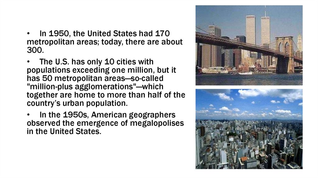
• In 1950, the United States had 170metropolitan areas; today, there are about
300.
• The U.S. has only 10 cities with
populations exceeding one million, but it
has 50 metropolitan areas—so-called
"million-plus agglomerations"—which
together are home to more than half of the
country’s urban population.
• In the 1950s, American geographers
observed the emergence of megalopolises
in the United States.
17.
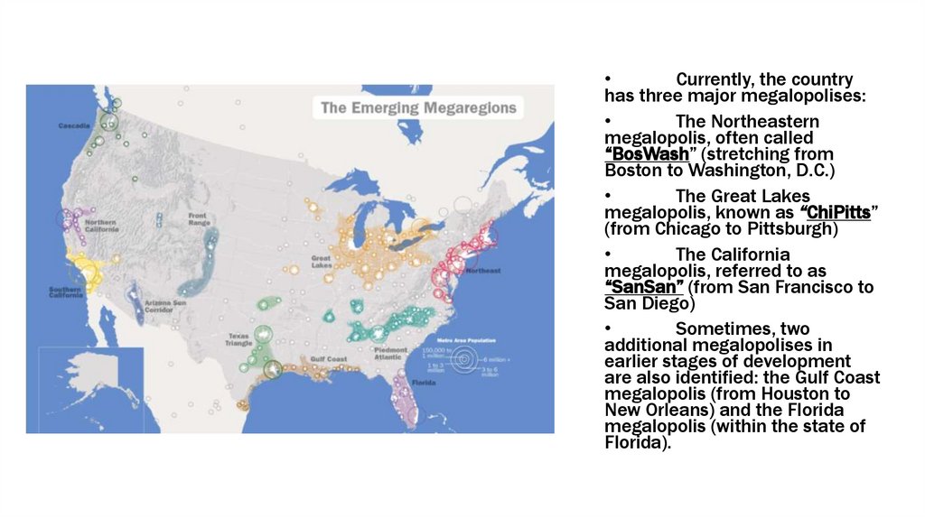
Currently, the country
has three major megalopolises:
The Northeastern
megalopolis, often called
“BosWash” (stretching from
Boston to Washington, D.C.)
The Great Lakes
megalopolis, known as “ChiPitts”
(from Chicago to Pittsburgh)
The California
megalopolis, referred to as
“SanSan” (from San Francisco to
San Diego)
Sometimes, two
additional megalopolises in
earlier stages of development
are also identified: the Gulf Coast
megalopolis (from Houston to
New Orleans) and the Florida
megalopolis (within the state of
Florida).
18. Low-Rise America
Suburban areas have expanded dramatically,
causing major U.S. cities to spread outward rather
than upward.
Today, two-thirds of all American families live
in this "single-story America," while populations in
city centers have been declining.
This trend has been driven by rising land prices,
worsening environmental conditions in urban cores,
the widespread availability of private automobiles,
and the strong cultural preference among
Americans to own their own home.
19. Rednecks` country
20. Hawaiian Islands
21. Rivers and Lakes
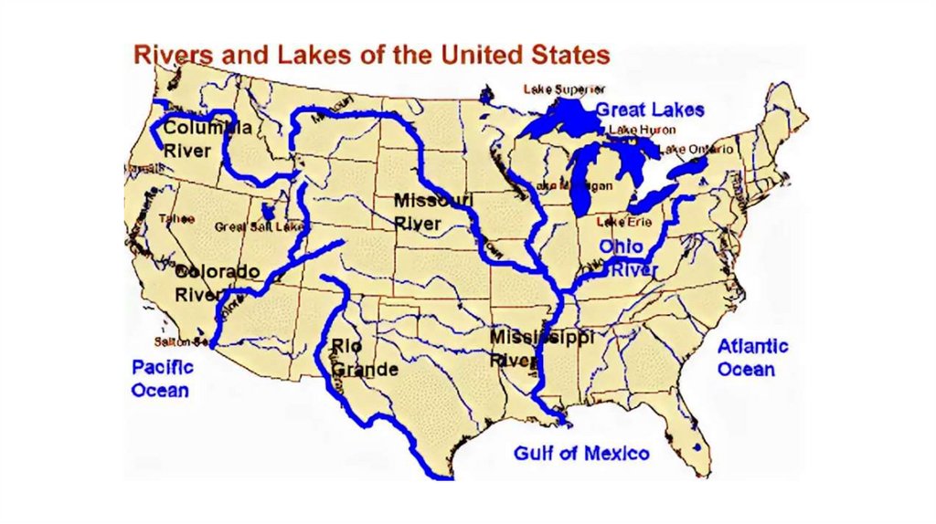
• Rivers in the United States drain into the basins of three oceans: the Pacific,the Atlantic, and the Arctic.
• Major lakes are located in the northern part of the country—the Great Lakes.
Smaller, landlocked saline lakes lie in depressions of the Great Basin. The
nation’s inland water resources are extensively used for industrial and
municipal water supply, irrigation, hydropower generation, and navigation.
• The majority of the country’s river discharge flows into the Gulf of Mexico,
part of the Atlantic Ocean. The largest river system is formed by the
Mississippi River (3,757 km long, with an annual discharge of 180 km³) and
its countless tributaries. The largest of these tributaries are the Missouri
River (4,127 km), the Arkansas River (2,364 km), and the Ohio River (1,579
km).
22.
23. Missisipi River
24. The Great Lakes
• The Great Lakes are a system of freshwater lakes in NorthAmerica, located on the border between the United States
and Canada. They consist of a series of large and mediumsized bodies of water interconnected by rivers and straits.
• Their total surface area is approximately 245,200 km², with a
water volume of about 22,700 km³.
• The five largest lakes—Superior, Huron, Michigan, Erie, and
Ontario—are considered the core of the Great Lakes system.
Several medium-sized lakes are also connected to this
system.
• The Great Lakes belong to the Atlantic Ocean basin, with their
outflow draining into the Atlantic via the St. Lawrence River.
25. Niagara Falls
• Niagara Falls is the collective name for three waterfalls on the Niagara River, which forms the borderbetween the U.S. state of New York and the Canadian province of Ontario. The falls consist of the
Horseshoe Falls (also known as the Canadian Falls), the American Falls, and the Bridal Veil Falls.
• Although the drop is not very high, the falls are extremely wide, and by volume of water flow, Niagara
Falls is the most powerful waterfall in North America.
• The total height of the falls is 53 meters. However, the base of the American Falls is obscured by a
large pile of rocks, making its visible drop only about 21 meters. The American Falls is 323 meters
wide, while the Horseshoe Falls spans 792 meters. The water flow can reach 5,700 cubic meters per
second or more.