


 history
 geography
Similar presentations:


History of state boarders changes in India
1.
History of state boarderschanges
NAME : DHAMOT NIRAJKUMAR GALABHAI
GROUP – 20LL5(a)
2.
Information• Name : History of state boarders changes
• Country : India
3.
History of boarders changes• Context: Seventy-two years after India’s independence, the country’s internal
boundaries continue to change.
• It’s been one year since the creation of two new Union territories (UTs) by
bifurcating the state of Jammu and Kashmir.
• India’s internal boundaries have undergone continuous evolution over the
past seven decades, as the charts below show.
• India’s external boundaries have in total changed only three times.
4.
History of boarders changeswhen Goa was subsumed into the Indian Union in 1961
When Pondicherry was subsumed in 1962 (officially) and
When Sikkim was subsumed in 1975.
There was territory loss to Pakistan (1947) and China (1962) but these areas
are still shown in India’s official map.
5.
States’ Reorganisation in India• While most regions in British India achieved independence on 15 August 1947, states, such
as Kashmir, Hyderabad, Junagadh, Manipur and Tripura, became part of the Union in
the period between 1947 and 1949.
By 26 January 1950, India had formally transitioned to a republic of states from a
dominion.
This union of states had three classifications based on
1. Whether they were former provinces (part A),
2.Princely states (part B), and
3.Territories that were going to be directly ruled by the Union government (part C), the
precursor to UTs.
6.
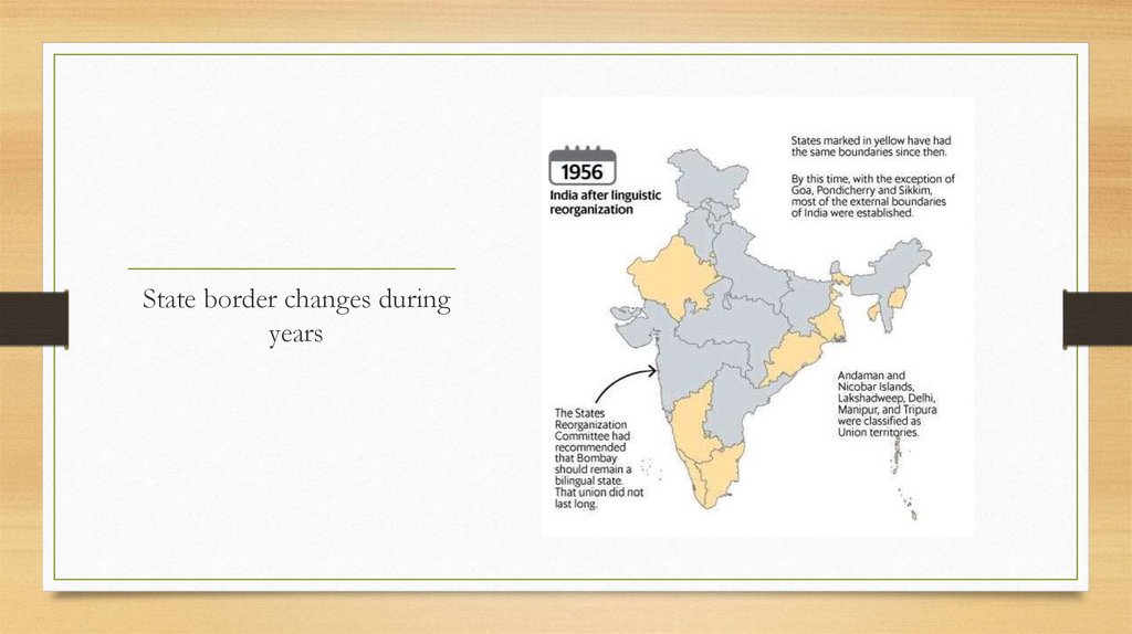
States’ Reorganisation in India• The biggest reorganization of India’s internal boundaries occurred in
1956 when an official States Reorganization Act was implemented. After
that, there were nine changes in state boundaries.
• In 1956, the country was organized into 14 states and six Union territories.
• Six states and five UTs still retain their boundaries from back then.
7.
State border changes during years8.
State border changes duringyears
9.
About States’ reorganisation in India• In 1947, India consisted of 571 princely states that were combined together to form 27
states on the basis of political and historical considerations.
• In 1948, SK Dhar commission was appointed by the government to study the need for
the reorganization of states on a linguistic basis.
• In 1948, the JVP Committee comprising Jawaharlal Nehru, Vallabh bhai Patel and
Pattabhi Sitaramayya rejected the idea of reorganisation of states on a linguistic basis.
• In 1953, the first linguistic state of Andhra for Telugu-speaking people was born after
the government was forced to separate the Telugu speaking areas from the state of Madras,
in the face of a prolonged agitation.
10.
About States’ reorganisation in India• The government did not agree with the recommendations fully but divided the country into
14 states and 6 union territories under the States Reorganisation Act, 1956.
• The states were Andhra Pradesh, Assam, Bihar, Bombay, Jammu and Kashmir, Kerala,
Madhya Pradesh, Madras, Mysore, Orissa, Punjab, Rajasthan, Uttar Pradesh and West
Bengal.
• The six union territories were Andaman and Nicobar Islands, Delhi, Himachal Pradesh,
Laccadive, Minicoy and Amindivi Islands, Manipur and Tripura.
• In 1960, Bombay state was divided to form the states of Gujarat and Maharashtra following
violence and protests.
11.
Conclusion• Throughout the independence of India India’s map and its external and
internal borders are keep changing.
• Folloing are the changes has been seen :
• As external borders – Goa, Pondicherry, Sikkim
• As internal borders – Kashmir, Hyderabad, Junagadh, Manipur and Tripira.