

 geography
Similar presentations:


Technical and commercial proposal. Geological study of Rio Muni area
1.
MALABO NOVEMBER 2020ZARUBEZHGEOLOGIA
TECHNICAL AND COMMERCIAL PROPOSAL
GEOLOGICAL STUDY OF RIO MUNI AREA, THE REPUBLIC OF EQUATORIAL GUINEA
STATE GEOLOGICAL MAPPING AT A SCALE OF 1: 200,000 WITH DETAILED SOLID MINERALS LOCATIONS FORECAST
Presented for:
Ministry of Mines and Hydrocarbons of
The Republic of Equatorial Guinea
JSC «ZARUBEZHGEOLOGIA»
Novocheremushkinskaya 69, Moscow, Russia
P: +7 495 669 66 10, E: info@zgeo.com
2.
+7 495 669 66 10info@zgeo.com
zargeo.eu
ZARUBEZHGEOLOGIA
1
CORE OBJECTIVES
BASIC TASKS
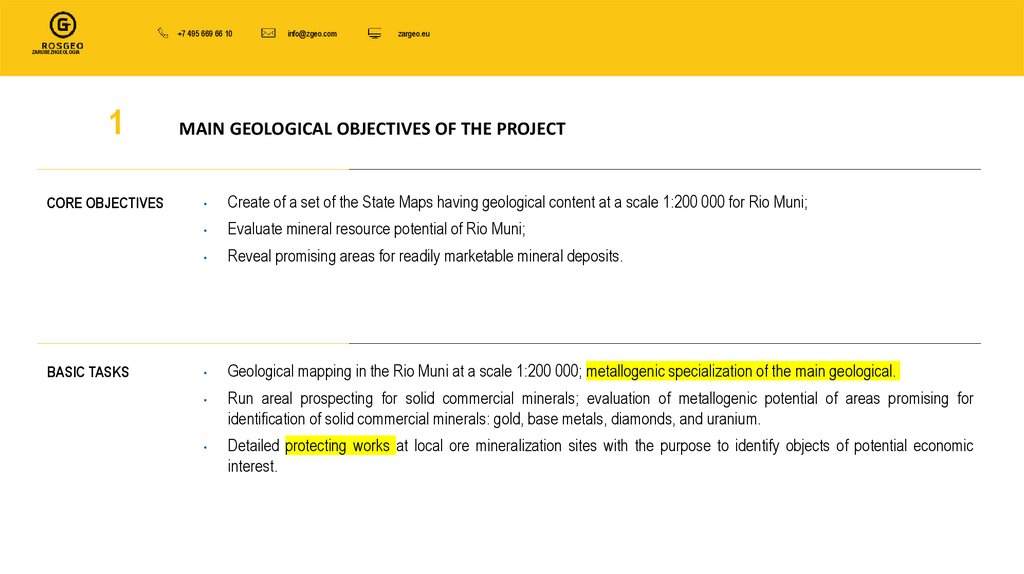
MAIN GEOLOGICAL OBJECTIVES OF THE PROJECT
Create of a set of the State Maps having geological content at a scale 1:200 000 for Rio Muni;
Evaluate mineral resource potential of Rio Muni;
Reveal promising areas for readily marketable mineral deposits.
Geological mapping in the Rio Muni at a scale 1:200 000; metallogenic specialization of the main geological.
Run areal prospecting for solid commercial minerals; evaluation of metallogenic potential of areas promising for
identification of solid commercial minerals: gold, base metals, diamonds, and uranium.
Detailed protecting works at local ore mineralization sites with the purpose to identify objects of potential economic
interest.
3.
+7 495 669 66 10info@zgeo.com
zargeo.eu
ZARUBEZHGEOLOGIA
2
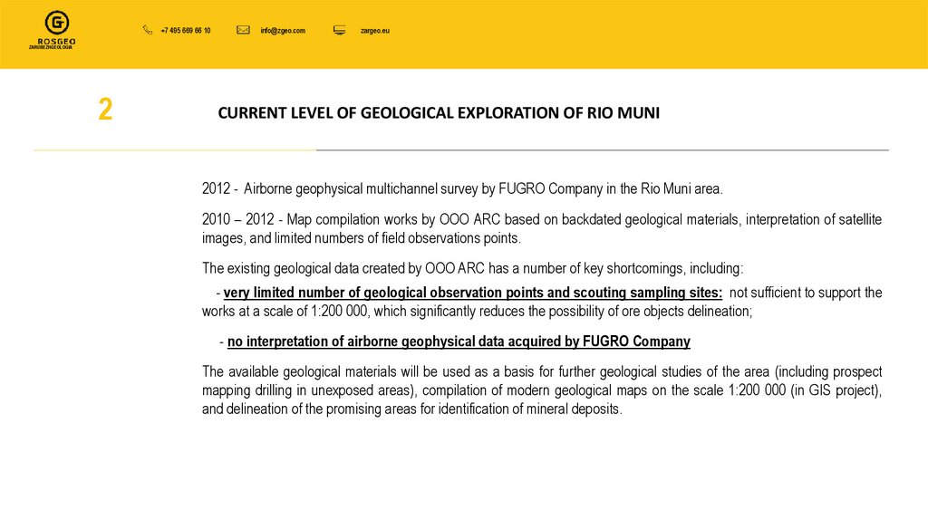
CURRENT LEVEL OF GEOLOGICAL EXPLORATION OF RIO MUNI
2012 - Airborne geophysical multichannel survey by FUGRO Company in the Rio Muni area.
2010 – 2012 - Map compilation works by OOO ARC based on backdated geological materials, interpretation of satellite
images, and limited numbers of field observations points.
The existing geological data created by OOO ARC has a number of key shortcomings, including:
- very limited number of geological observation points and scouting sampling sites: not sufficient to support the
works at a scale of 1:200 000, which significantly reduces the possibility of ore objects delineation;
- no interpretation of airborne geophysical data acquired by FUGRO Company
The available geological materials will be used as a basis for further geological studies of the area (including prospect
mapping drilling in unexposed areas), compilation of modern geological maps on the scale 1:200 000 (in GIS project),
and delineation of the promising areas for identification of mineral deposits.
4.
+7 495 669 66 10info@zgeo.com
zargeo.eu
ZARUBEZHGEOLOGIA
3
SCOPE OF WORK
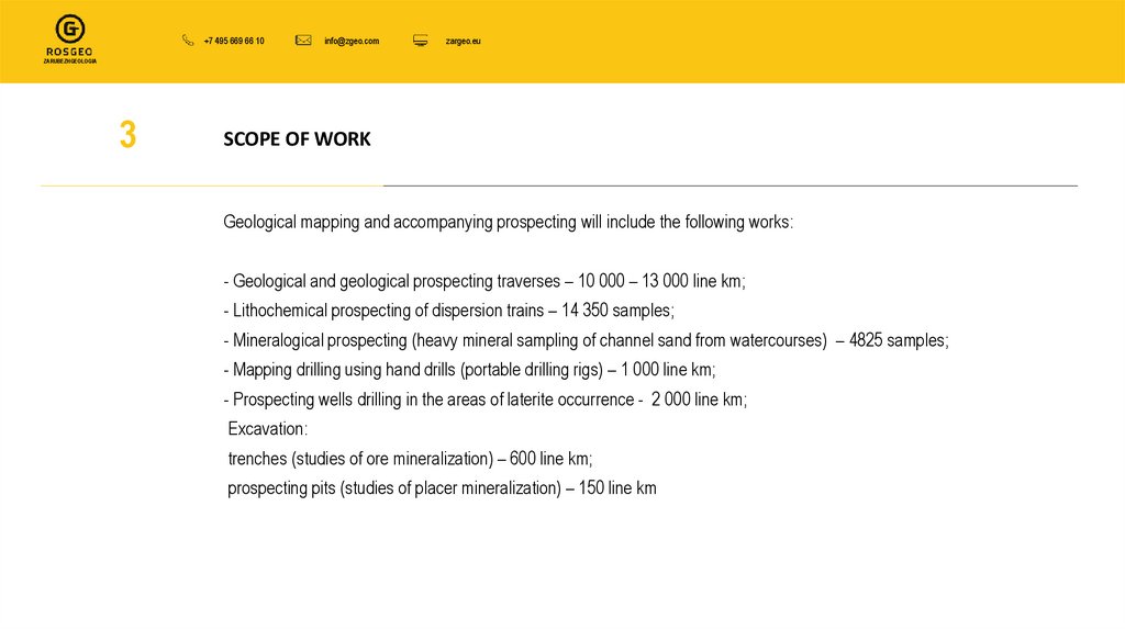
Geological mapping and accompanying prospecting will include the following works:
- Geological and geological prospecting traverses – 10 000 – 13 000 line km;
- Lithochemical prospecting of dispersion trains – 14 350 samples;
- Mineralogical prospecting (heavy mineral sampling of channel sand from watercourses) – 4825 samples;
- Mapping drilling using hand drills (portable drilling rigs) – 1 000 line km;
- Prospecting wells drilling in the areas of laterite occurrence - 2 000 line km;
Excavation:
trenches (studies of ore mineralization) – 600 line km;
prospecting pits (studies of placer mineralization) – 150 line km
5.
+7 495 669 66 10info@zgeo.com
zargeo.eu
ZARUBEZHGEOLOGIA
4
DELIVERABLES
Set of updated state-of-the-art geological maps (including GIS) at a scale 1:200 000, including:
WHAT WILL OBTAIN
THE CUSTOMER AS A
WORK RESULTS
Detailed Geological Maps at a scale 1:200 000 of the Republic of Equatorial Guinea (Rio Muni) — two sheets;
Map of Minerals at a scale 1:200 000 of the Republic of Equatorial Guinea (Rio Muni) — two sheets;
Map of Location Trends and Forecast of Mineral Occurrences at a scale 1:200 000 of the Republic of Equatorial Guinea
(Rio Muni) — two sheets.
Explanatory Notes to the Geological Map, the Map of Minerals, and the Map of Location Trends and Forecast of Mineral
Occurrences at a scale 1:200 000 of the Republic of Equatorial Guinea (Rio Muni) — two sheets.
Geological Maps of the promising subsoil areas at scales 1 : 2 000 – 1 : 10 000;
Book of the promising objects ranked according to priority of further studies.
6.
+7 495 669 66 10info@zgeo.com
zargeo.eu
ZARUBEZHGEOLOGIA
5
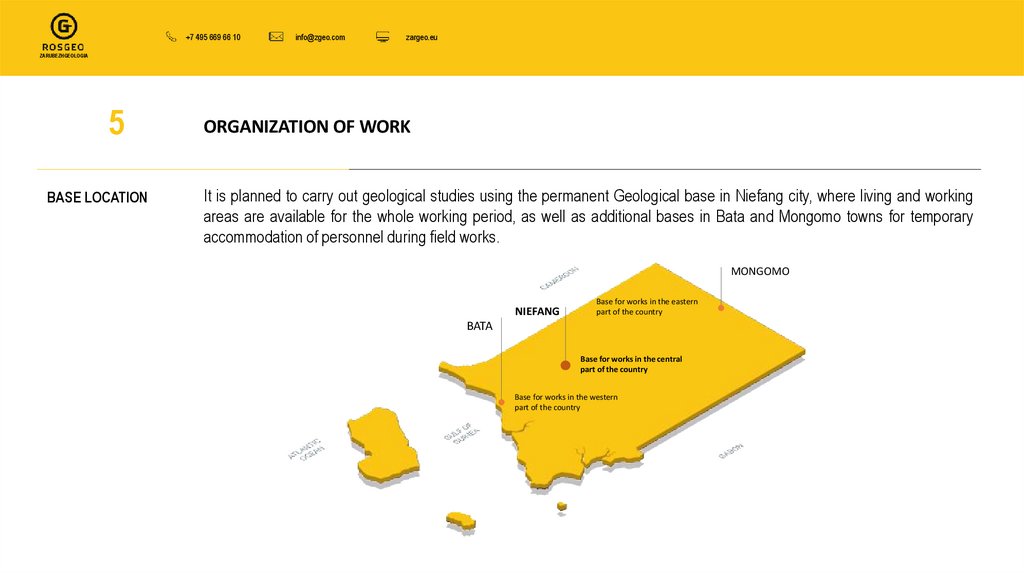
BASE LOCATION
ORGANIZATION OF WORK
It is planned to carry out geological studies using the permanent Geological base in Niefang city, where living and working
areas are available for the whole working period, as well as additional bases in Bata and Mongomo towns for temporary
accommodation of personnel during field works.
MONGOMO
NIEFANG
Base for works in the eastern
part of the country
BATA
Base for works in the central
part of the country
Base for works in the western
part of the country
7.
+7 495 669 66 10info@zgeo.com
zargeo.eu
ZARUBEZHGEOLOGIA
6
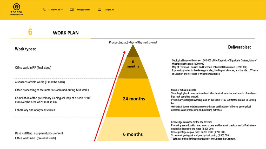
WORK PLAN
Prospecting activities of the next project
Deliverables:
Work types:
Office work in RF (final stage)
6
months
Geological Map on the scale 1:200 000 of the Republic of Equatorial Guinea, Map of
Minerals on the scale 1:200 000
Map of Trends of Location and Forecast of Mineral Occurrence (1:200 000)
Explanatory Notes to the Geological Map, the Map of Minerals, and the Map of Trends
of Location and Forecast of Mineral Occurrence
4 seasons of field works (3 months each)
Office processing of the materials obtained during field works
Laboratory and analytical studies
Maps of actual materials
Sampling logbook: heavy mineral and lithochemical samples, and results of analyses.
Bed rock sampling logbook
Preliminary geological working map on the scale 1:100 000 for the area of 26 000 sq
km
Geological documentation on ground-based verification of airborne geophysical
anomalies and prospecting and checking activities
Base outfitting, equipment procurement
Office work in RF (pre-field study)
Knowledge database for the Rio territory
Promising areas location map in accordance with data of previous works Preliminary
geological legend to the maps (1:200 000).
Space photogeological maps on the scale (1:200 000)
Scheme of geological and geophysical zoning (1:500 000).
Technical project for implementation of work under the Contract.
Compilation of the preliminary Geological Map at a scale 1:100
000 over the area of 26 000 sq km.
24 months
6 months
8.
+7 495 669 66 10info@zgeo.com
zargeo.eu
ZARUBEZHGEOLOGIA
7
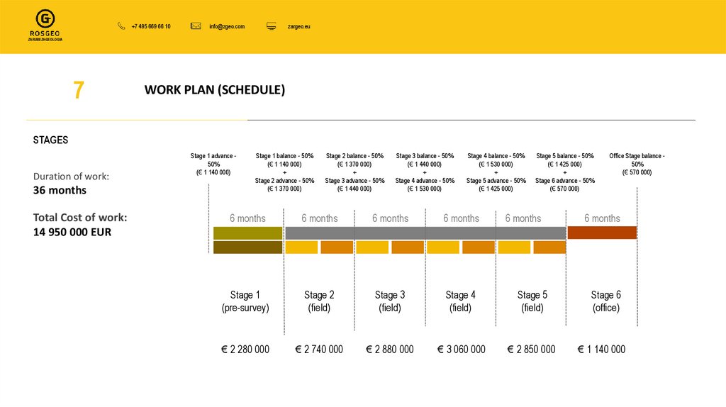
WORK PLAN (SCHEDULE)
STAGES
Duration of work:
36 months
Total Cost of work:
14 950 000 EUR
Stage 1 advance 50%
(€ 1 140 000)
Stage 1 balance - 50%
(€ 1 140 000)
+
Stage 2 advance - 50%
(€ 1 370 000)
Stage 2 balance - 50%
(€ 1 370 000)
+
Stage 3 advance - 50%
(€ 1 440 000)
Stage 3 balance - 50%
(€ 1 440 000)
+
Stage 4 advance - 50%
(€ 1 530 000)
Stage 4 balance - 50%
(€ 1 530 000)
+
Stage 5 advance - 50%
(€ 1 425 000)
Stage 5 balance - 50%
(€ 1 425 000)
+
Stage 6 advance - 50%
(€ 570 000)
6 months
6 months
6 months
6 months
6 months
Stage 1
(pre-survey)
Stage 2
(field)
Stage 3
(field)
Stage 4
(field)
Stage 5
(field)
€ 2 280 000
€ 2 740 000
€ 2 880 000
€ 3 060 000
€ 2 850 000
Office Stage balance 50%
(€ 570 000)
6 months
Stage 6
(office)
€ 1 140 000
9.
+7 495 669 66 10info@zgeo.com
zargeo.eu
ZARUBEZHGEOLOGIA
8
4 FIELD SQUADS
Field Squads
TEAM 1
Head of exploration group
Senior geologist
Geologist
Geological engineer
3 workers
TEAM 2
Head of exploration group
Senior geologist
Geologist
Geological engineer
3 workers
TOTAL: 7 persons
TOTAL: 7 persons
TEAM 3
TEAM 4
Senior mapping geologist
Geologist
Geological engineer
3 workers
Senior mapping geologist
Geologist
Geological engineer
3 workers
TOTAL: 6 persons
TOTAL: 6 persons
10.
+7 495 669 66 10info@zgeo.com
zargeo.eu
ZARUBEZHGEOLOGIA
9
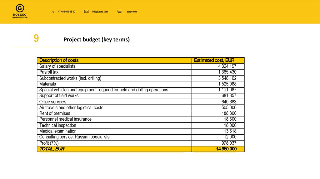
Project budget (key terms)
Description of costs
Salary of specialists
Payroll tax
Subcontracted works (incl. drilling)
Materials
Special vehicles and equipment required for field and drilling operations
Support of field works
Office services
Air travels and other logistical costs
Rent of premises
Personnel medical insurance
Technical inspection
Medical examination
Consulting service, Russian specialists
Profit (7%)
TOTAL, EUR
Estimated cost, EUR
4 324 197
1 385 430
3 548 102
1 525 088
1 111 087
681 857
640 683
505 000
188 300
18 600
18 000
13 618
12 000
978 037
14 950 000