


 english
Similar presentations:


")


Geography of the UK
1.
GEOGRAPHY OFTHE UK
Lecture 2
2. Plan
1. General information2. Geographical components and borders
3. Natural regions and topography
3.1. The highland zone
3.2. The lowland zone
3.3. Rivers and lakes
3.4. Coastline
4. Climate
5. Plant life
6. Animal life
7. Natural resources
7.1. Soils
7.2. Mineral resources
7.3. Energy resources
3. 1. General information
The United Kingdom is a constitutional monarchy innorthwestern Europe, officially the United Kingdom of Great
Britain and Northern Ireland.
4. 1. General information
Great Britainis the largest island in the
cluster of islands, or
archipelago,
known as the British Isles.
England is the largest and
most
populous division of
the island of
Great Britain, making up the
south and east.
5. 1. General information
Wales is on thewest and Scotland is to the
north. Northern Ireland is located
in the northeast corner of
Ireland, the second largest island
in the British Isles. The capital of the United Kingdom is the city of
London, situated near the southeastern tip of England.
6. 1. General information
The United Kingdom is a small nation inphysical size.
At
244,110 sq km (94,251 sq mi), the
United Kingdom is roughly the size
of Oregon or Colorado, or twice the size
of New York State.
To
compare, Ukraine has an area of 233,100
sq mi (603,700 sq km).
7. 1. General information
The climate, in general, ismild, chilly, and often wet. Rain
or overcast skies can be expected
for
up to 300 days per year. These
conditions make Britain lush and
green, with rolling plains in the
south and east and rough hills
and
mountains to the west and north.
Despite its relatively small size,
Britain is highly populated, with
an estimated population density
of
251 persons per sq km (650 per
sq mi) in 2006. The UK
population
was 61.8 million in 2009.
8. 1. General information
The United Kingdom is divided into four constituentparts,
commonly referred to as the home nations: England,
Wales, Scotland,
and Northern Ireland.
9. 1. General Information
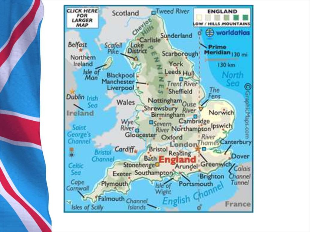
Most of England consists of rolling lowland terrain, divided eastfrom west by more mountainous terrain in the northwest
(Cumbrian
Mountains of the Lake District) and north (the upland moors of the
Pennines) and limestone hills of the Peak District by the Tees-Exe
line.
Камберле́ндские
Пеннинские горы — невысокие горы в
го́ры
Великобритании, расположенные в северной
(англ. Cumbrian Англии. Отделяют Северо-Западную Англию
Mountains) —
от Йоркшира и Северо-Восточной Англии.
горный массив на
Озёрный край — горный регион в
западе
Пик-Дистрикт —
Северо-Западной Англии, в графстве
Великобритании.
возвышенная местность
Камбрия. Территория историкоВысшая точка
в центральной и
культурной области практически
массива — гора
северной Англии
совпадает с Камберлендскими горами.
Скофел-Пайк (978м).
Озёрный край знаменит своими
живописными горными и озёрными
ландшафтами.
10. 1. General information
The main rivers and estuaries arethe Thames, Severn and the Humber
Estuary.
Се́верн — самая длинная река в
Великобритании. Длина течения реки
составляет 354 километра.
Ха́мбер — эстуарий на восточном
побережье, образованный реками Трент и Уз
в Англии.
Те́мза — река на юге Великобритании.
Длина — 334 км, площадь бассейна —
15,3 тыс. км².
11. 1. General Information
The largest urban area is GreaterLondon.
12. 1. General Information
Near Dover, the Channel Tunnel links the United Kingdom with France.There is no peak in England that is 1000 metres (3,300 ft) or greater. To the
southwest of England are the Isles of Scilly, and to the south is the Isle of
Wight.
Силли – небольшой архипелаг в 45 км к
юго-западу от графства Корнуолл
Евротоннель, тоннель под Ла-Маншем —
железнодорожный двухпутный тоннель,
длиной около 51 км, из которых 39 км
проходит под проливом Ла-Манш.
Соединяет континентальную Европу с
Великобританией железнодорожным
сообщением
Дувр — город и порт в Великобритании, в
английском графстве Кент, у пролива Па-деКале, связан железнодорожным паромом с
Дюнкерком.
Остров Уайт — самый большой остров у
побережья Англии
13.
14. 1. General Information
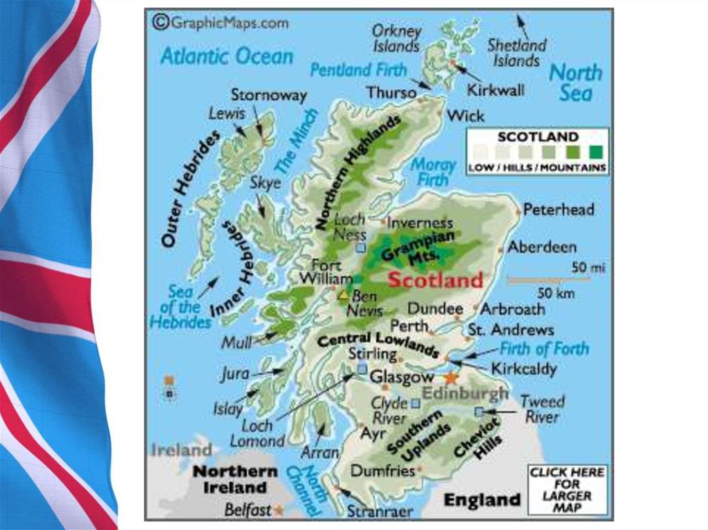
Scotland’s geography is varied, with lowlands in the south and eastand highlands in the north and west, including
Ben Nevis, the UK’s highest mountain at
1343 metres (4,406 ft). There are many
long and deep-sea arms, firths, and lochs.
A multitude of islands west and north of Scotland are also included,
notably the Hebrides, Orkney Islands and Shetland Islands. The
capital city is Edinburgh, the centre of which is a World Heritage Site.
The largest city is Glasgow.
Бен-Не́вис — гора в Грампианских горах
Гебри́дские острова́ — архипелаг в
Атлантическом океане у западных берегов
Шотландии.
Оркне́йские острова́ — архипелаг в 16 км от
северной оконечности Шотландии,
состоящий из более 70 островов, из которых
обитаемы около 20
Шетла́ндские острова́ — архипелаг на
северо-востоке Шотландии.
15.
16. 1. General Information
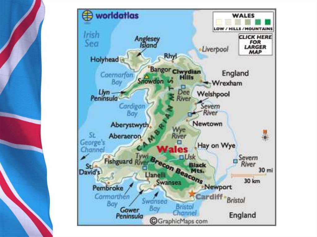
• Wales is mostly mountainous, the highest peak being Snowdonat 1085 metres (3,560 ft) above sea level. North of the
mainland is the island of Anglesey. The largest and capital city
is Cardiff, located in South Wales
Сно́удон — самая высокая гора Уэльса,
высочайшая вершина Великобритании
южнее Шотландского высокогорья.
А́нглси — остров в Уэльсе, на котором
расположена унитарная административная
единица Уэльса со статусом графства Айлоф-Англси
17.
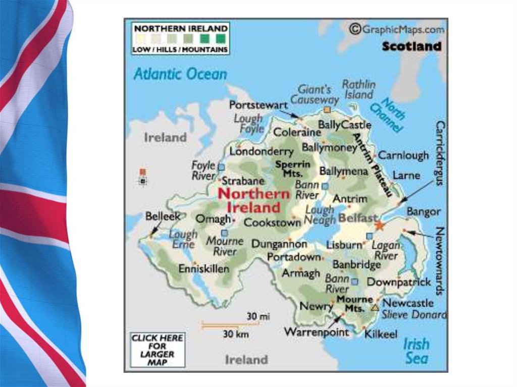
18. 1. General Information
• Northern Ireland, making up the north-eastern part of Ireland, ismostly hilly. The main cities are Belfast and Londonderry (also known
as Derry). The province is home to one of the UK’s World Heritage
Sites, the Giant’s Causeway, which consists of more than 40,000 sixsided
basalt columns up to 40 feet (12 m) high. Lough Neagh, the
largest body of water in the British Isles, by surface area (396 square
kilometres), can be found in Northern Ireland.
«Мостовая гигантов», или Доро́га гига́нтов
— памятник природы из примерно 40 000
соединённых между собой базальтовых
колонн, образовавшихся в результате
древнего извержения вулкана
Лох-Ней — пресноводное озеро в Северной
Ирландии.
19.
20. 1. General Information
• In total it is estimated that the UK includesaround 1098 small
islands, some being natural and some being
crannogs, a type of
artificial island which was built in past times
using stone and wood,
gradually enlarged by natural waste building
up over time
21. 2. Geographical components and borders
The United Kingdom isbordered on the south by the
English
Channel, which separates it
from Europe. It is bordered on
the east
by the North Sea, and on the
west by the Irish Sea (the North
Channel
and St George’s Channel) and
the Atlantic Ocean. The United
Kingdom’s only land border
with another nation is between
Northern
Ireland and Ireland.
22. 2. Geographical components and borders
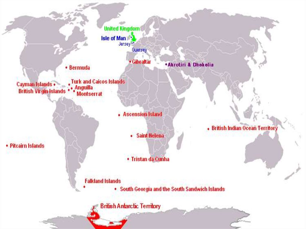
• Several dependencies and dependent territories are associatedwith the United Kingdom. The dependencies, located close to Britain,
are the Isle of Man in the Irish Sea and the Channel Islands off the
northern coast of France. These dependencies, while not technically part
of the United Kingdom, maintain a special relationship with it. The
Channel Islands – the two largest islands being Jersey and Guernsey – were
once part of the Duchy of Normandy and retain much of their original
French culture. The Isle of Man, controlled by Norway during the Middle
Ages, came under English rule in the 14th century. Both dependencies are
largely self-governing and have their own legislative assemblies and
systems of law. Britain is responsible for their international relations and
defense
23.
24. 2.2. The correct usage of the names of the country
As a matter of fact, the various terms used to describe thedifferent (and sometimes overlapping) geographical and political
regions of the islands traditionally referred to collectively as the
British Isles are often a source of confusion for people from other
parts of the world, and even for the inhabitants of those islands
themselves.
The following brief list of names serves the purpose of explaining the
meanings of and inter-relationships between those
terms
25.
• Britain’s dependent territories are scattered throughout theworld and are the remains of the former British Empire. They are
generally small in area and without many resources. Today Britain
assists the territories economically, with the understanding that they
may become independent when they wish. Most are locally self-governing,
although the queen appoints a governor for each territory
who is responsible for external affairs and internal security, including
the police and public service. The ultimate responsibility for their
government rests with the foreign and commonwealth secretary, a
minister in the British Cabinet. The United Kingdom has experienced
difficulties with some of its territories – Argentina has made claims to
the Falkland Islands (Spanish Islas Malvinas) and Spain has made
claims to Gibraltar. China’s claim to the former dependent territory of
Hong Kong was satisfied in July 1997 when Britain’s lease ran out
and China assumed control of the area.
26. 3. Natural regions and topography
The traditional division of Great Britain is into a Highlandand Lowland zone. A line running from the mouth of the
River Exe, in the southwest, to that of the Tees, in the
northeast, is a crude expression of this division. The course
of the 700-foot (213-metre) contour, or of the boundary
separating the older rocks of the north and west from the
younger southeastern strata, provides more appropriate
indications of the extent of the Highlands.