


 geography
Similar presentations:


Oceanography (Океанография)
1.
OceanographyОкеанография
2.
Секция I:Рельеф океанов
Section I:
Ocean landforms
3.
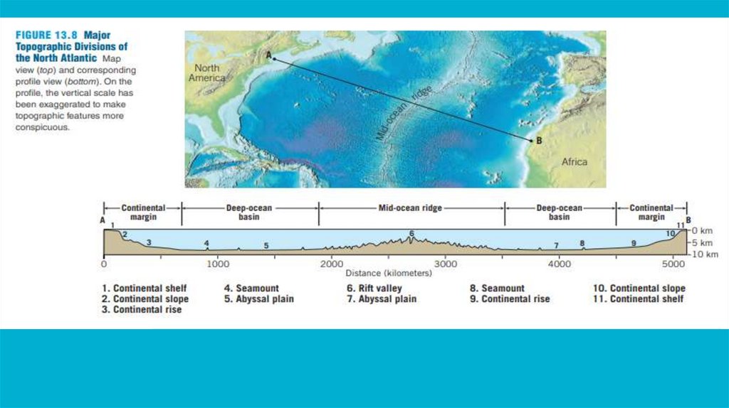
4.
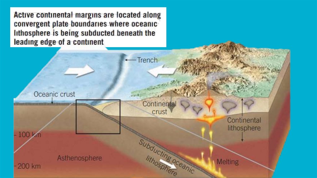
Формы рельефа пассивных континентальныхграниц
5.
Submarine canyonsSubmarine canyons are steep-sided valleys or gorges that cut through the continental shelf and
slope, and extend down to the deep ocean floor. There are several theories on how submarine
canyons form, and the exact process can vary depending on the location and geology of the
canyon. Some of the main theories include:
1. Erosion by turbidity currents: Turbidity currents are underwater avalanches of sediment
that can flow down the continental slope and into the deep sea. As they move, they can erode
the seafloor and carve out canyons. This is known as the turbidity current hypothesis, and it is
one of the most widely accepted explanations for the formation of submarine canyons.
2. Tectonic activity: Some submarine canyons may form as a result of tectonic activity, such as
the movement of tectonic plates or the formation of faults. This can create fractures in the
seafloor that allow water and sediment to flow through, leading to the formation of canyons.
3. Glaciation: During periods of glaciation, large ice sheets can erode the seafloor and create
valleys that later become canyons. This is known as the glacial erosion hypothesis.
4. Submarine groundwater discharge: Submarine canyons may also form as a result of the
discharge of groundwater into the ocean. This can cause erosion and the formation of
channels that later become canyons.
Overall, the formation of submarine canyons is likely a complex process that can be
influenced by a variety of factors, including geological activity, ocean currents, and climate.
More research is needed to fully understand the mechanisms behind the formation of these
features.
6.
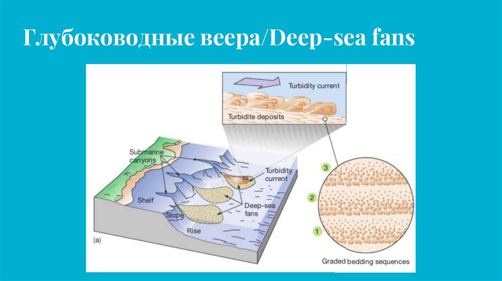
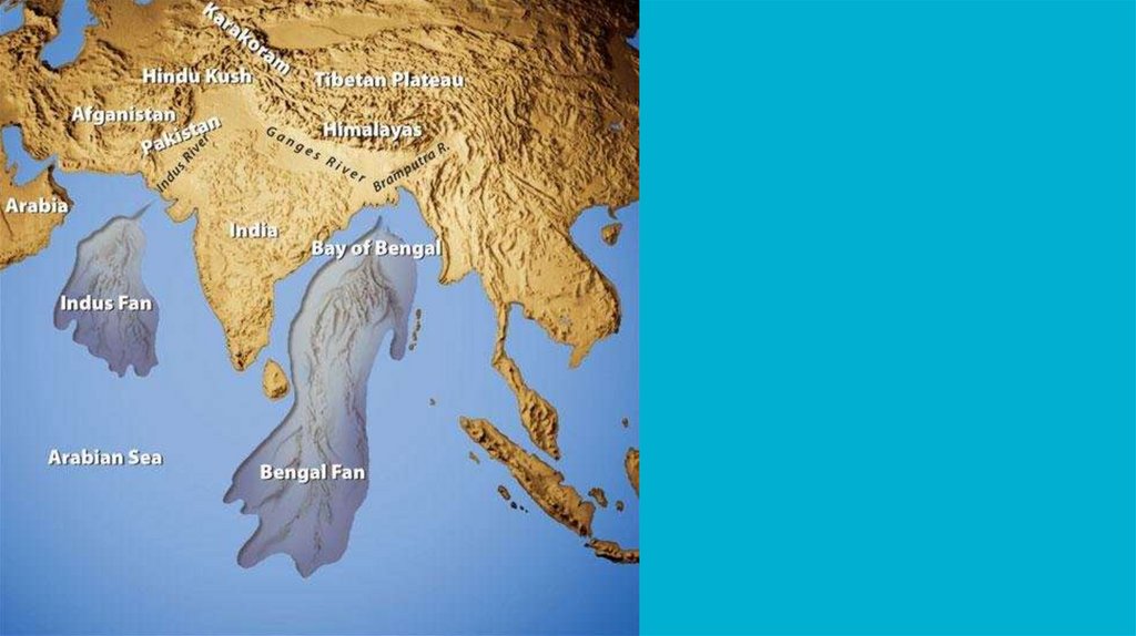
Глубоководные веера/Deep-sea fans7.
8.
9.
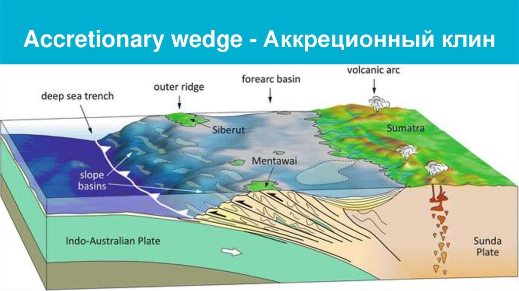
Accretionary wedge - Аккреционный клин10.
An accretionary wedge is a geologic structure that forms at the boundary between two convergingtectonic plates, where one plate is subducting beneath the other. As the subducting plate sinks into
the mantle, it creates a zone of compression and deformation in the overlying plate, leading to the
formation of a wedge-shaped mass of sediment and rock. This wedge, known as an accretionary
wedge, is composed of materials scraped off the subducting plate, such as sediments, volcanic
rocks, and pieces of oceanic crust.
Over time, the accretionary wedge can become quite large, and in some cases, it can rise above
sea level to form islands. This can occur when the wedge is uplifted by tectonic forces or when sea
level falls due to climate change or other factors. Some examples of islands that have formed from
accretionary wedges include:
1.The Aleutian Islands: The Aleutian Islands are a chain of volcanic islands that extend from Alaska
into the Pacific Ocean. They were formed by the subduction of the Pacific Plate beneath the North
American Plate, which created an accretionary wedge of volcanic rocks and sediments.
2.The Caribbean Islands: The Caribbean Islands are a chain of islands that arc from the Bahamas
in the north to Trinidad in the south. They were formed by the subduction of the North American
Plate and the South American Plate beneath the Caribbean Plate, which created an accretionary
wedge of sediment and volcanic rocks.
3.The Philippines: The Philippines are an archipelago of more than 7,000 islands located in
Southeast Asia. They were formed by the subduction of the Philippine Plate beneath the Eurasian
Plate, which created an accretionary wedge of volcanic rocks and sediments.
Overall, accretionary wedges can form islands if they are uplifted or if sea level falls, and there are
11.
Образование атоллов12.
Секция II:Температура, солёность, и прочие
свойства
Section II:
Temperature, salinity, and other properties
13.
14.
15.
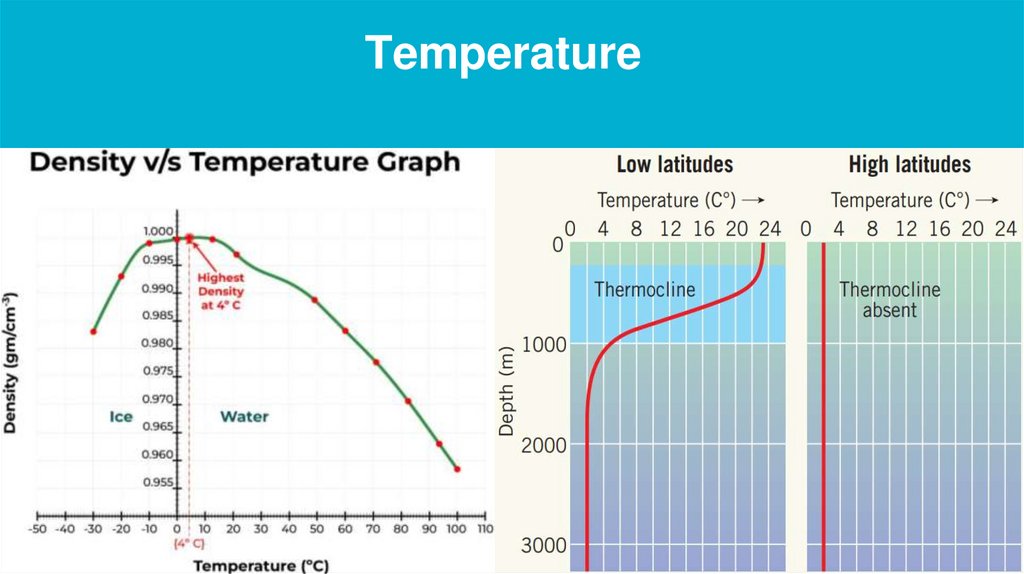
Temperature16.
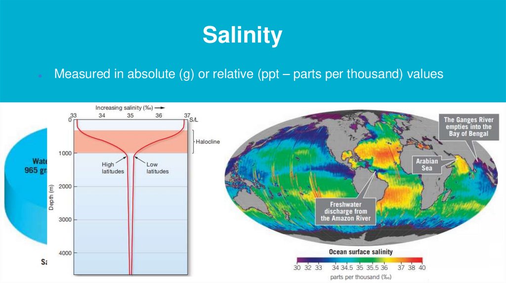
SalinityMeasured in absolute (g) or relative (ppt – parts per thousand) values
17.
Density18.
19.
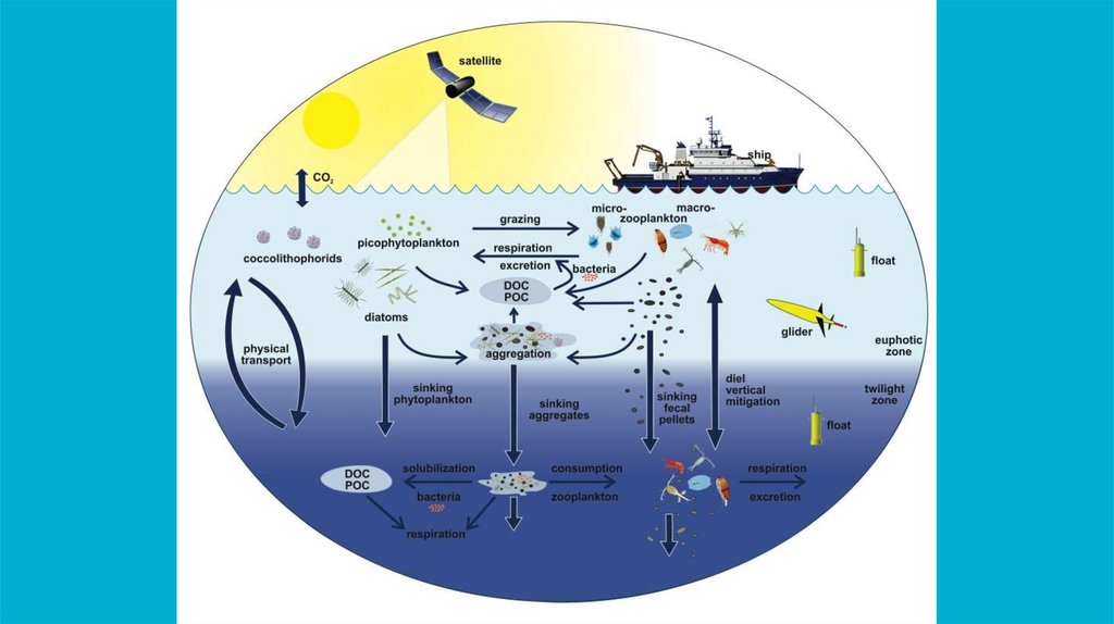
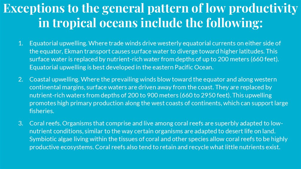
Ocean productivity20.
Секция III:Морские течения
Section III:
Ocean currents
21.
22.
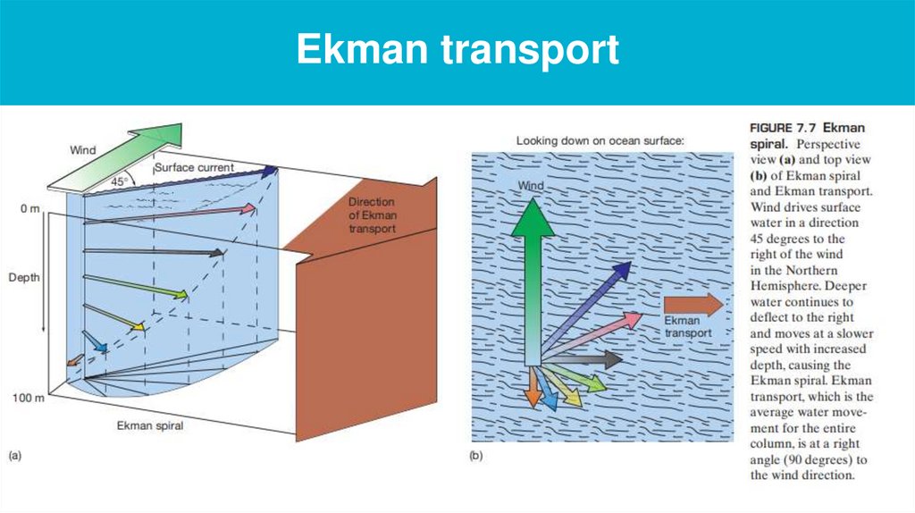
Ekman transport23.
Upwelling24.
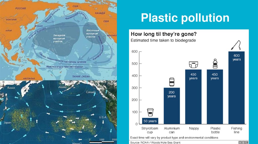
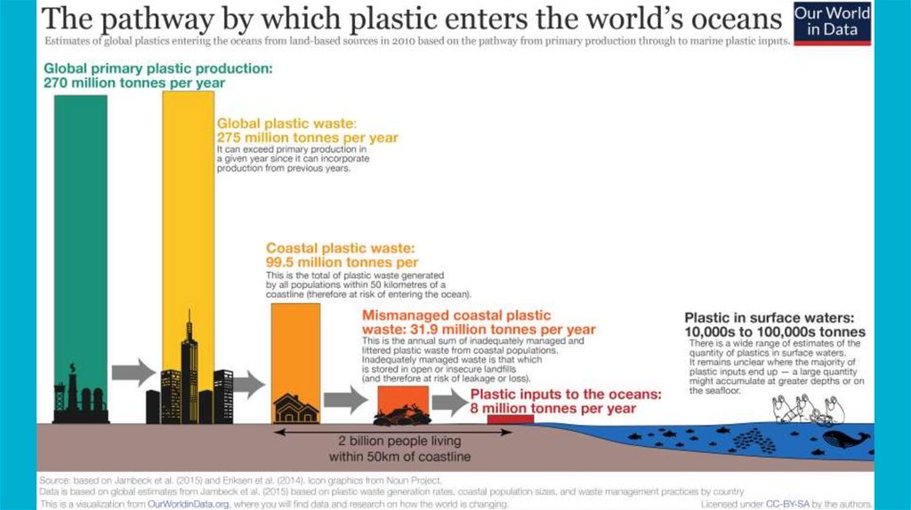
Plastic pollution25.
26.
Plastic pollutionhttps://www.youtube.com/watch?v=fsjvwQclGLo
27.
Секция IV:Морские осадки
Section IV:
Marine sediments
28.
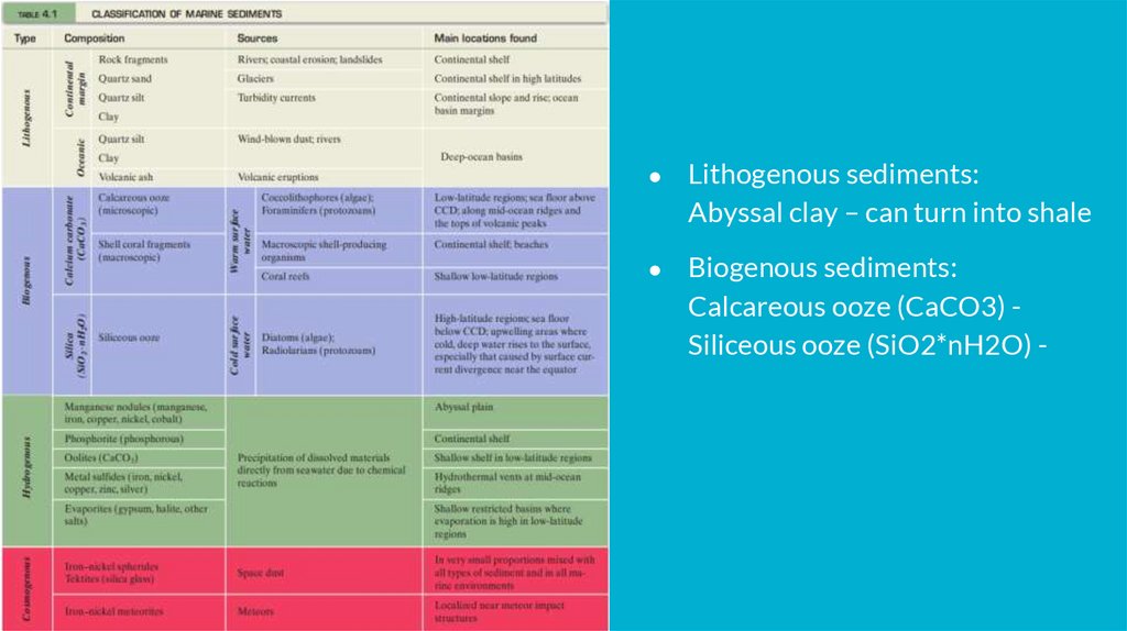
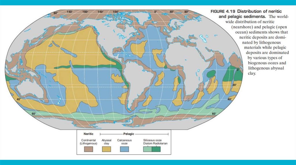
Classification of marine sedimentsMarine sedimentary deposits can be categorized as either neritic or pelagic.
Neritic (neritos: of the coast) deposits are found on continental shelves and in
shallow water near islands; these deposits are generally coarse grained.
Alternatively, pelagic (pelagios: of the sea) deposits are found in the deep
ocean basins and are typically fine grained. Moreover, lithogenous sediment in
the ocean is ubiquitous: At least a small percentage of lithogenous sediment is
found nearly everywhere on the ocean floor
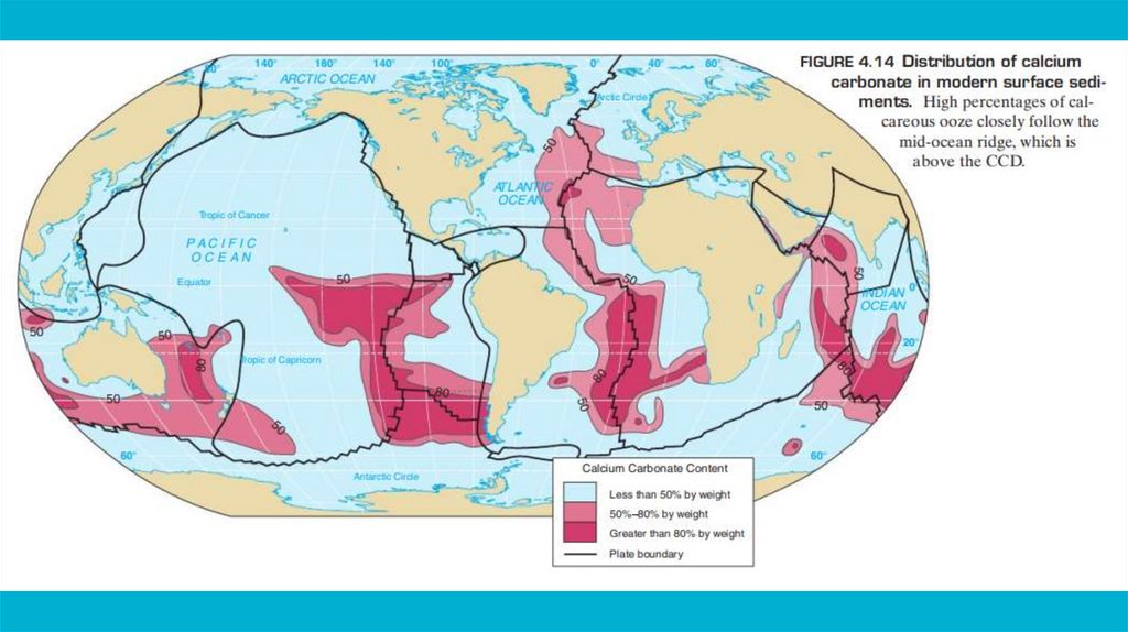
29.
Lithogenous sediments:
Abyssal clay – can turn into shale
Biogenous sediments:
Calcareous ooze (CaCO3) Siliceous ooze (SiO2*nH2O) -
30.
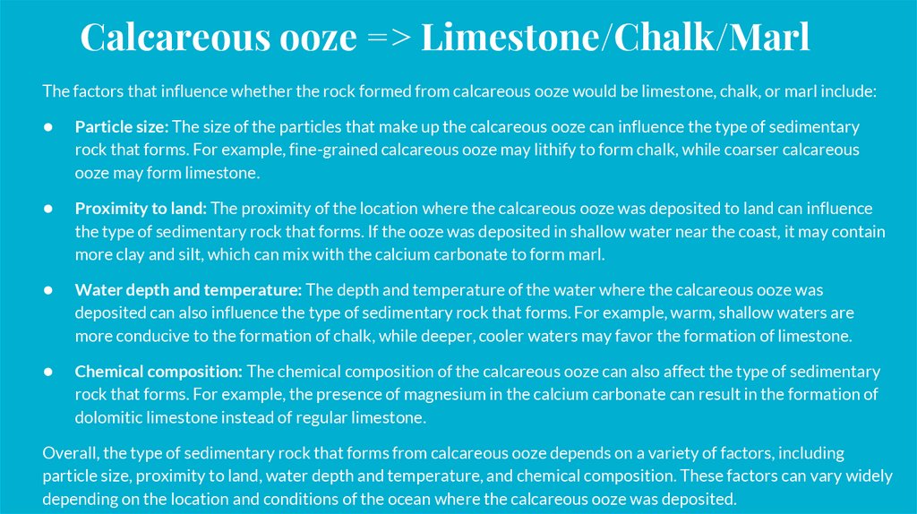
Calcareous ooze => Limestone/Chalk/MarlThe factors that influence whether the rock formed from calcareous ooze would be limestone, chalk, or marl include:
Particle size: The size of the particles that make up the calcareous ooze can influence the type of sedimentary
rock that forms. For example, fine-grained calcareous ooze may lithify to form chalk, while coarser calcareous
ooze may form limestone.
Proximity to land: The proximity of the location where the calcareous ooze was deposited to land can influence
the type of sedimentary rock that forms. If the ooze was deposited in shallow water near the coast, it may contain
more clay and silt, which can mix with the calcium carbonate to form marl.
Water depth and temperature: The depth and temperature of the water where the calcareous ooze was
deposited can also influence the type of sedimentary rock that forms. For example, warm, shallow waters are
more conducive to the formation of chalk, while deeper, cooler waters may favor the formation of limestone.
Chemical composition: The chemical composition of the calcareous ooze can also affect the type of sedimentary
rock that forms. For example, the presence of magnesium in the calcium carbonate can result in the formation of
dolomitic limestone instead of regular limestone.
Overall, the type of sedimentary rock that forms from calcareous ooze depends on a variety of factors, including
particle size, proximity to land, water depth and temperature, and chemical composition. These factors can vary widely
depending on the location and conditions of the ocean where the calcareous ooze was deposited.
31.
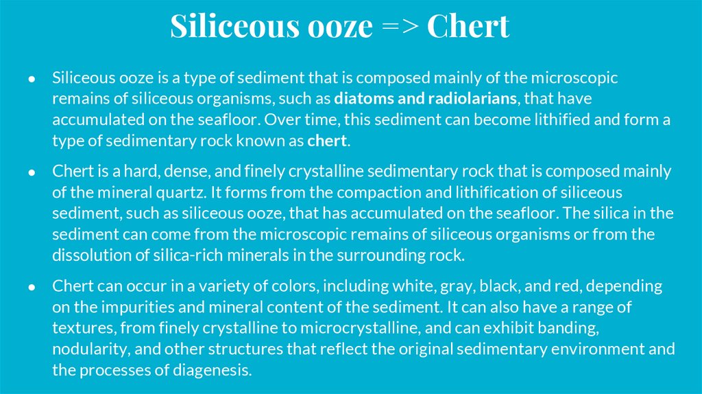
Siliceous ooze => ChertSiliceous ooze is a type of sediment that is composed mainly of the microscopic
remains of siliceous organisms, such as diatoms and radiolarians, that have
accumulated on the seafloor. Over time, this sediment can become lithified and form a
type of sedimentary rock known as chert.
Chert is a hard, dense, and finely crystalline sedimentary rock that is composed mainly
of the mineral quartz. It forms from the compaction and lithification of siliceous
sediment, such as siliceous ooze, that has accumulated on the seafloor. The silica in the
sediment can come from the microscopic remains of siliceous organisms or from the
dissolution of silica-rich minerals in the surrounding rock.
Chert can occur in a variety of colors, including white, gray, black, and red, depending
on the impurities and mineral content of the sediment. It can also have a range of
textures, from finely crystalline to microcrystalline, and can exhibit banding,
nodularity, and other structures that reflect the original sedimentary environment and
the processes of diagenesis.
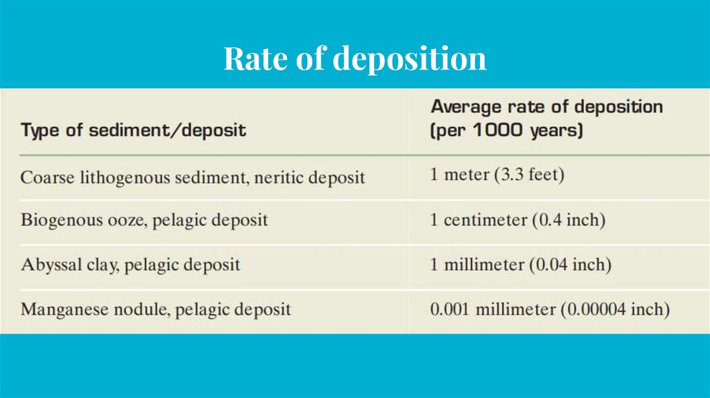
32.
Rate of deposition33.
34.
35.
36.
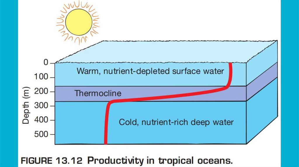
37.
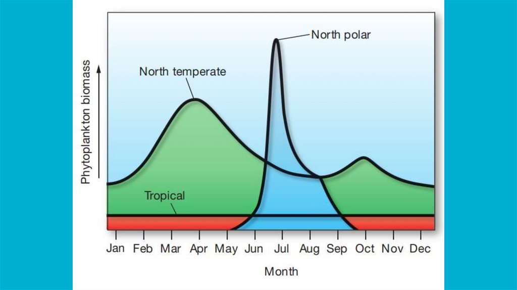
Exceptions to the general pattern of low productivityin tropical oceans include the following:
1.
Equatorial upwelling. Where trade winds drive westerly equatorial currents on either side of
the equator, Ekman transport causes surface water to diverge toward higher latitudes. This
surface water is replaced by nutrient-rich water from depths of up to 200 meters (660 feet).
Equatorial upwelling is best developed in the eastern Pacific Ocean.
2.
Coastal upwelling. Where the prevailing winds blow toward the equator and along western
continental margins, surface waters are driven away from the coast. They are replaced by
nutrient-rich waters from depths of 200 to 900 meters (660 to 2950 feet). This upwelling
promotes high primary production along the west coasts of continents, which can support large
fisheries.
3.
Coral reefs. Organisms that comprise and live among coral reefs are superbly adapted to lownutrient conditions, similar to the way certain organisms are adapted to desert life on land.
Symbiotic algae living within the tissues of coral and other species allow coral reefs to be highly
productive ecosystems. Coral reefs also tend to retain and recycle what little nutrients exist.
38.
Секция V:Биогеография океанов
Section V:
Biogeography of the oceans
39.
40.
Pelagic
Neritic
Benthic
41.
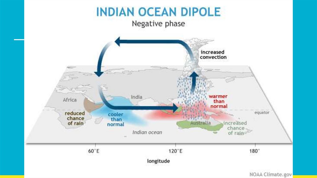
Секция VI:Эль-Ниньо и Индийский диполь
Section VI:
El-Nino (ENSO) and Indian dipole
42.
43.
44.
45.
Секция VII:Приливы и отливы
Section VII:
Tides
46.
47.
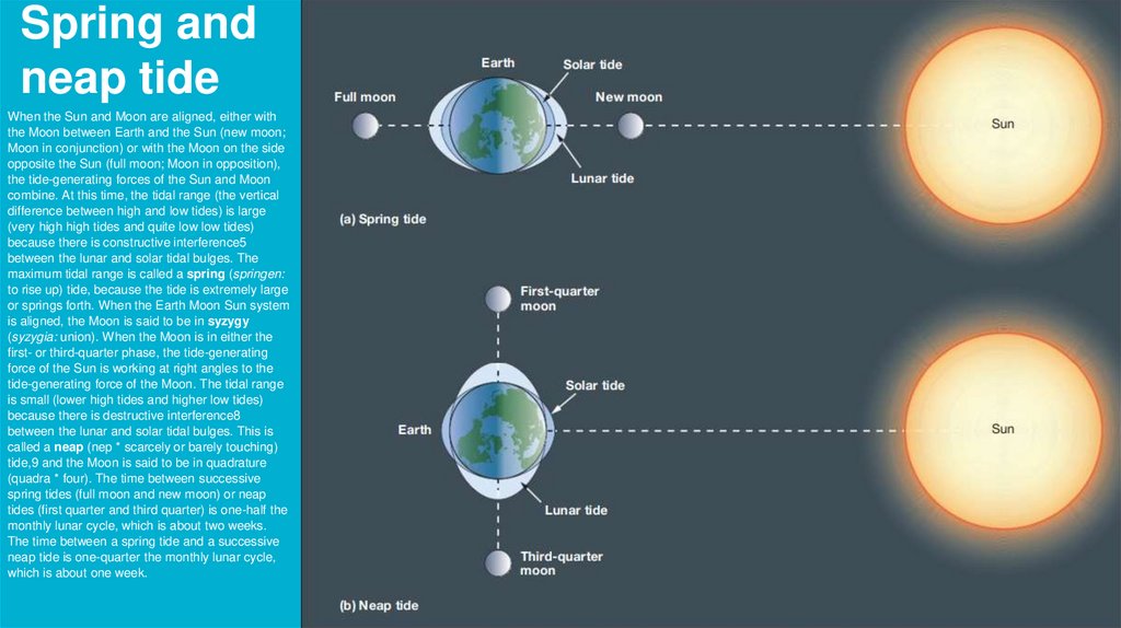
Spring andneap tide
When the Sun and Moon are aligned, either with
the Moon between Earth and the Sun (new moon;
Moon in conjunction) or with the Moon on the side
opposite the Sun (full moon; Moon in opposition),
the tide-generating forces of the Sun and Moon
combine. At this time, the tidal range (the vertical
difference between high and low tides) is large
(very high high tides and quite low low tides)
because there is constructive interference5
between the lunar and solar tidal bulges. The
maximum tidal range is called a spring (springen:
to rise up) tide, because the tide is extremely large
or springs forth. When the Earth Moon Sun system
is aligned, the Moon is said to be in syzygy
(syzygia: union). When the Moon is in either the
first- or third-quarter phase, the tide-generating
force of the Sun is working at right angles to the
tide-generating force of the Moon. The tidal range
is small (lower high tides and higher low tides)
because there is destructive interference8
between the lunar and solar tidal bulges. This is
called a neap (nep * scarcely or barely touching)
tide,9 and the Moon is said to be in quadrature
(quadra * four). The time between successive
spring tides (full moon and new moon) or neap
tides (first quarter and third quarter) is one-half the
monthly lunar cycle, which is about two weeks.
The time between a spring tide and a successive
neap tide is one-quarter the monthly lunar cycle,
which is about one week.
48.
49.
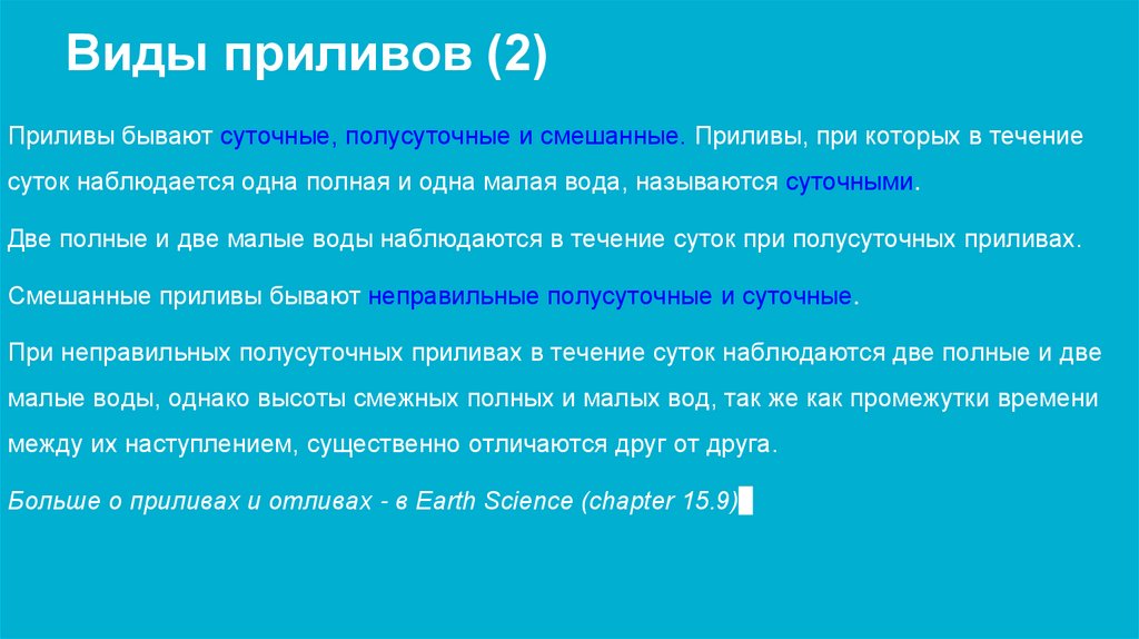
Виды приливов (2)Приливы бывают суточные, полусуточные и смешанные. Приливы, при которых в течение
суток наблюдается одна полная и одна малая вода, называются суточными.
Две полные и две малые воды наблюдаются в течение суток при полусуточных приливах.
Смешанные приливы бывают неправильные полусуточные и суточные.
При неправильных полусуточных приливах в течение суток наблюдаются две полные и две
малые воды, однако высоты смежных полных и малых вод, так же как промежутки времени
между их наступлением, существенно отличаются друг от друга.
Больше о приливах и отливах - в Earth Science (chapter 15.9).
50.
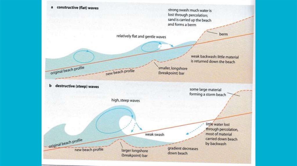
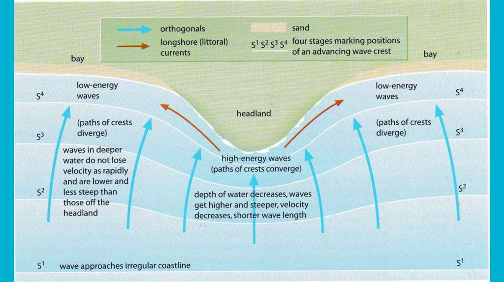
Секция VIII:Волны и берега
Section VIII:
Waves and coasts
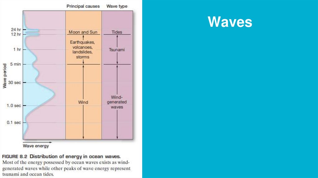
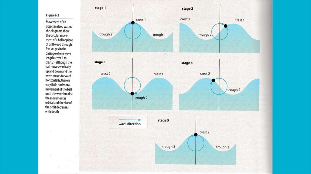
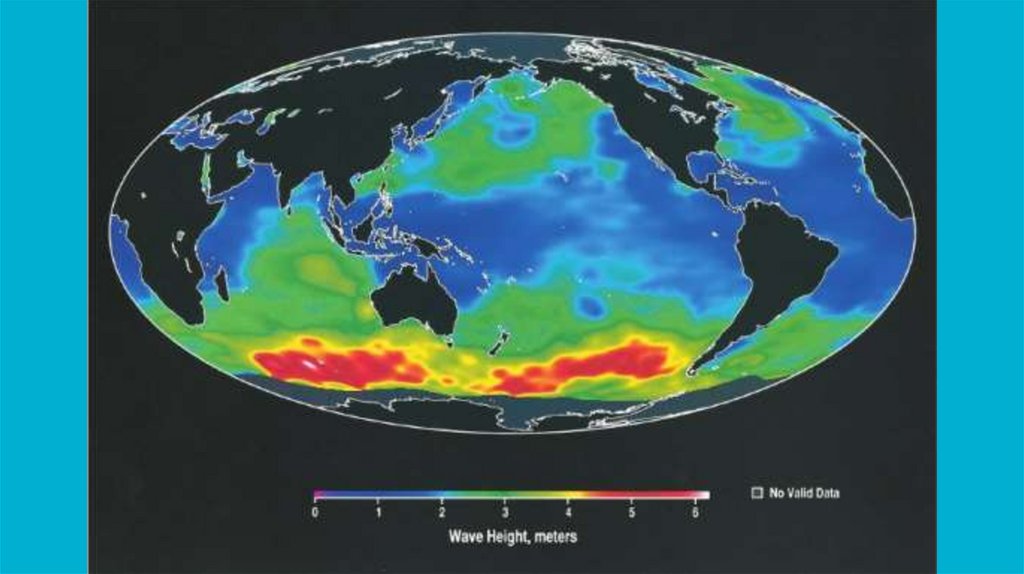
51.
Waves52.
Берега океанов. Пляжи.53.
54.
55.
56.
57.
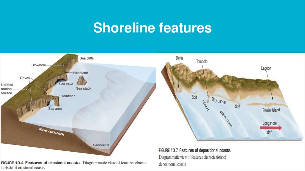
Shoreline features58.
Секция IX:Экологические проблемы океанов
Section IX:
Ecological issues of the oceans
59.
60.
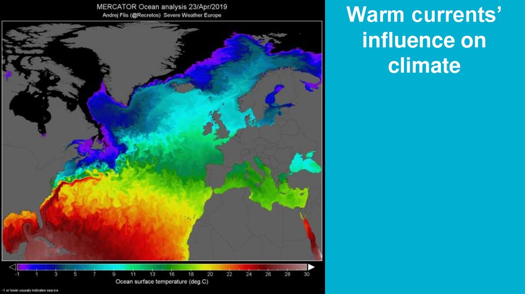
Warm currents’influence on
climate
61.
62.
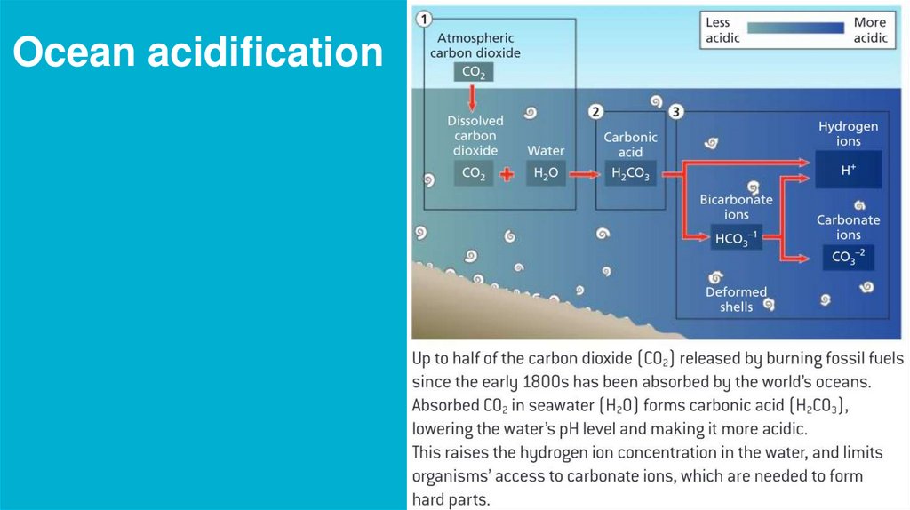
Ocean acidification63.
Climate change refers to the long-term changes in the Earth's climate, including global warming, sea-level rise, and changes in precipitation patterns,which are primarily caused by human activities, such as burning fossil fuels, deforestation, and land-use changes. These human activities are
increasing the concentration of greenhouse gases, primarily carbon dioxide (CO2), in the atmosphere, which traps heat and results in global warming.
Positive feedback relationships in climate change refer to processes that amplify warming, while negative feedback relationships refer to processes that
reduce warming. Some examples of positive feedback mechanisms include:
•Melting of sea ice: As global warming melts sea ice, less ice reflects sunlight, and more of it is absorbed by the dark ocean, which further warms the
Earth's surface, leading to even more sea ice melting.
•Thawing permafrost: Permafrost is frozen soil that stores large amounts of carbon. As permafrost thaws, microorganisms decompose the organic
matter, releasing carbon dioxide and methane, which are potent greenhouse gases that further warm the Earth's atmosphere.
•Decreased snow cover: Snow reflects sunlight, but as snow cover decreases due to global warming, more sunlight is absorbed by the Earth's surface,
leading to further warming.
Some examples of negative feedback mechanisms include:
•Carbon dioxide fertilization: As carbon dioxide concentrations increase in the atmosphere, plants grow faster and absorb more carbon dioxide, which
reduces the amount of carbon dioxide in the atmosphere, thus slowing global warming.
•Increased cloud cover: As the Earth warms, more water evaporates from the ocean, leading to increased cloud cover. Clouds reflect sunlight back into
space, which cools the Earth's surface, thus reducing warming.
Major variables involved in the process of climate change include:
•Greenhouse gases: The concentration of greenhouse gases, primarily carbon dioxide, in the atmosphere is the primary driver of climate change.
•Solar radiation: Changes in the amount of solar radiation reaching the Earth can cause climate to change, although this is a relatively minor factor
compared to human activities.
•Ocean currents: Changes in ocean currents can cause regional climate changes, such as the El Niño-Southern Oscillation.
•Land use changes: Deforestation and other land use changes can release large amounts of carbon dioxide into the atmosphere and affect regional
climate.
Minor variables involved in the process of climate change include:
•Atmospheric aerosols: Tiny particles in the atmosphere can scatter sunlight and affect regional climate.
•Volcanic eruptions: Large volcanic eruptions can release large amounts of sulfur dioxide into the atmosphere, which can reflect sunlight and cool the
Earth's surface.
•Natural variations: Natural variations in climate, such as changes in the Earth's orbit or the strength of the sun, can cause climate to change over long
periods of time.
In conclusion, climate change is a complex and multifaceted phenomenon that involves many variables and feedback relationships. While there are
some negative feedback mechanisms that can slow global warming, the positive feedback mechanisms are more numerous and more potent, which
64.
65.
Bioaccumulation and biomagnificationEssentials of Oceanography, Chapter 11
66.
Секция X:Круговороты веществ в природе (C, P, N)
Section X:
Cycle of elements (C, P, N)
67.
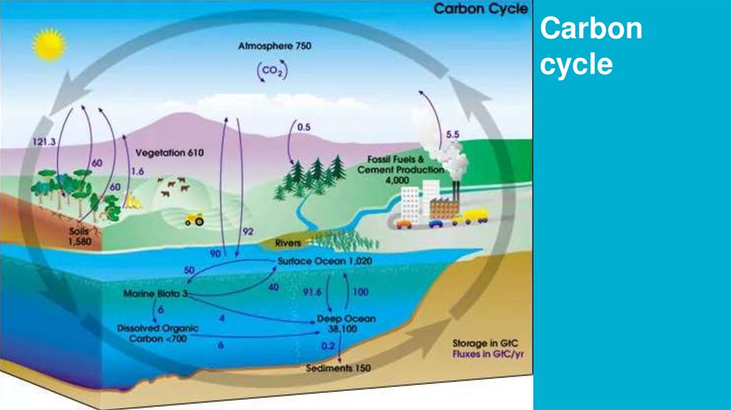
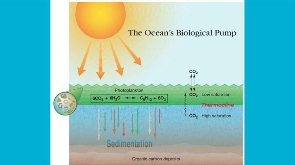
Carboncycle
68.
69.
70.
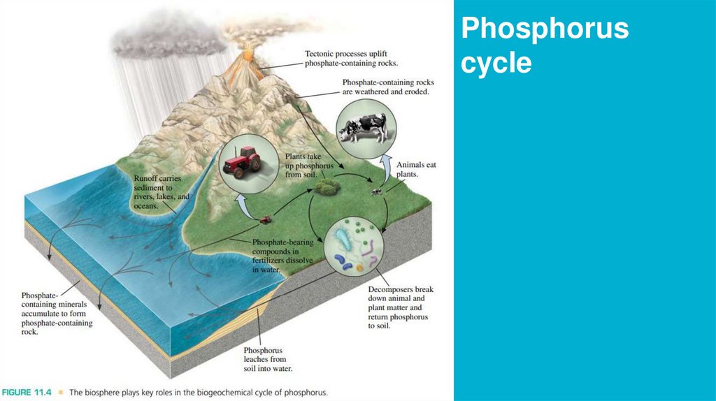
Phosphoruscycle
71.
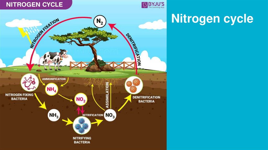
Nitrogen cycle72.
73.
74.
“Essentials of Oceanography”, Alan P. Trujillo,Harold V. Thurman
Paragraphs: 1.3-1.6
Paragraphs: 5-16